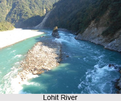
 Lohit River or Zayu River flows through the Indian state of Arunachal Pradesh. It originates in eastern Tibet, in the Zayal Chu range and surges through Arunachal Pradesh for 200 kilometers, before emptying itself in the plains of Assam. Uncontrolled and turbulent are the features of the Lohit River. The lateritic soil of the river forms its surrounding demography. The river flows through the Mishmi Hills, to meet the Siang at the head of the Brahmaputra valley. Lohit River is used by the Indian Army for various kinds of expeditions and trainings. This region experiences a mix of many cultures near the tri-point between Tibet, Southeast Asia and South Asia.
Etymology of Lohit River
The Lohit River has derived its name because of its vigorous nature and thus it is also called the "river of blood".
Beauty of Lohit River
The valley of the Lohit is a lovely, green place. Thickly forested area and alpine vegetation give way to sub-tropical forests. Some of the densest tropical jungles in all over the India are found in this area. The rhododendrons bloom in many hues along the upper course of the river; the orchids reveal themselves in the lower course. The banks of Lohit River are indeed a treasure house of medicinal plant, herbs, Mishmi teeta, and coptis plant; it is known in all over the world for its best medicinal properties. The Mishmis hold sway in the hills; along the lower valleys of these hills the Lohit river flows. In the plains there are towns like Khamptis and the Singphos, where enthusiastic Buddhists and migrants from across the Patkai hills from Burma reside.
Religious Significance of Lohit River
A Hindu pilgrimage known as Parshuram Kund is nestled on the lower reaches of Lohit. This holy site is very famous among the devotees. Every year on the occasion of Makar Sankranti, in the month of January more than 70,000 devotees and sadhus take holy dip in its water.
Sports Attractions of Lohit River
Lohit River offers certain sports facilities like rafting and kayaking etc. However, there have been very few raft and kayak expeditions on the river. The first rafting was experienced in February 1994 by the Indian Army and the first successful kayak was tried in December 2003.


