Home > Indian History > Geography of India > Bindusagar Lake
Bindusagar Lake
Bindusagar Lake is one of the popular attractions of Bhubaneshwar. It is a famous sacred lake of Odisha.

Share this Article:

Bindusagar Lake is one of the scared places in Bhubaneshwar which is also known as the "Bindu Sarovar and" Ocean Drop Tank". The lake serves as a focal point around which numerous temples of Bhubaneshwar are located. It is believed that this pristine lake stored many drops of water from every sacred rivers, pools and tanks in India. The Bindusagar Lake is about 1300 ft in length and 700 ft in width. The banks of the lake are covered with beautiful stones which enhance its charm. At one time, over 7,000 temples bordered the Bindusagar Lake in Bhubaneshwar, out of which only 500 still survive, all built in the Kalinga style architecture.
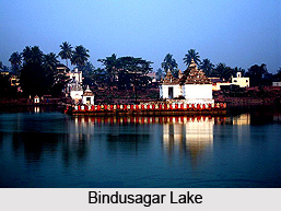
Bindusagar Lake, Odisha Mythological Significance of Bindusagar Lake
With immense mythological significance to its credit, Bindusagar Lake stands as the major landmark in a city that is abundantly blessed with historic temples. Infact, the lake has been gaining tremendous popularity amongst the tourists as a picnic spot. A vast number of architectural treasures find existence in the area surrounding this huge water body. Lying to the north of the Lingaraja Temple and to the east of the Ananta Vasudeva Temple, the Bindusagar Lake is one of the popular tourist attractions of Bhubaneshwar. Every year, the idol of Lord Lingaraja (Lord Shiva) is brought to the lake for a ritual bath held during the annual Car festival (Ashokashtami). People believe that when a person takes a dip in the Bindusagar Lake, the holy water washes away all his sins and the devotees get rid of all their diseases by drinking the holy water. There is a very interesting legend associated with the creation of the Bindusagar Lake of Orissa.

Legend of Bindusagar Lake
As per the legend, Lord Shiva expressed his preference for Bhubaneshwar, over Benaras, in front of his consort, Goddess Parvati. She disguised herself as a cowherd woman and went to look at the city. On the way, she met two demons, "Kritti" and "Vasa", who expressed a wish to marry her. She asked them to carry her on their shoulders and when they did so, she crushed them under her weight. It was at this time that Lord Shiva created the lake to quench her thirst.


Share this Article:

Related Articles

More Articles in Geography of India


Geography of Uttar Pradesh
The fourth largest State in India UP is located in the Northern part of India whose area is 2,36,286 sq Kms.
Geography of Maharashtra
Covering an area of 308,000 sq. km, Maharashtra, the third largest state in India.
Geography of Kerala
Geography of Kerala includes plains, hills, valleys and coasts. With the Arabian Sea in the west, the Western Ghats in the east and networked by several rivers, Kerala enjoys diverse geographical features.
Geography of West Bengal
The geography of West Bengal is unique with high peaks of the Himalayan range in the north, the Bay of Bengal in the south and the remaining region is covered with both plains and plateaus.
Geography of Jharkhand
Geography of Jharkhand is comprised of the rich mineral resources and the highly agricultural prospect in this state.
Geography of Sikkim
Geography of Sikkim is characterised by a vast array of magnificent hillock that extends from one corner of the state to the other.
Geography of Meghalaya
The suitable climate, highland plateaus, rivers and the flora and fauna together forms the geography of Meghalaya.
Geography of Mizoram
Mizoram is surrounded by hills, valleys, rivers, waterfalls and lakes. The hills range from 1000 meters to 2000 meters. Rivers, lakes and waterfalls also play major role in forming the land of Mizoram.
Geography of Jammu & Kashmir
Jammu and Kashmir is encompassed by valleys. Some of the dominant valleys of the state are Kashmir Valley, Tawi Valley, Chenab Valley, Poonch Valley, Sind Valley and Lidder Valley etc. Jhelum River is the only major Himalayan River which flows through the Kashmir valley. Indus, Tawi, Ravi and Chenab Rivers are the major ones flowing through the region.
Geography of Daman and Diu
Daman and Diu is situated on the west coast of India and are the smallest union territories of India.
Geography of Goa
Geography of Goa occupies a prime location along the Konkan coastal belt on the western coast of India. The state is bordered by Maharashtra in the north and Karnataka in the south. The Western Ghats in the east contribute to the flora and fauna of Goa.
Geography of Arunachal Pradesh
Geography of Arunachal Pradesh reveals that it is a hilly tract nestled in the foot of Himalayas.
Geography of Kutch
Geography of Kutch District is covering an area of 45,612 km. Kutch District is the largest district in the state of Gujarat.
Geography of Ladakh
Geography of Ladakh mainly comprises the huge Karakoram Range with long stretch of cold desert which mark the region separately from the rest of the states of Indian subcontinent. Surrounded with the mountain ranges from all corners this small region separates Indian subcontinent from rest of the Asian continent.
Geography of Rajasthan
Geography of Rajasthan defines the dry topography with arid climate of the western mountain region.
Geography of Tamil Nadu
The Indian state of Tamil Nadu is located in the Northern hemisphere in the hot zone.