Home > Indian History > Geography of India > Pakhal Lake
Pakhal Lake
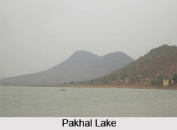
Pakhal Lake in Telangana is a man made lake in Pakhal Bird Sanctuary. The lake is constructed in a small tributary of Krishna River and situated amidst rippled hilly topography.

Share this Article:

Pakhal Lake, Warangal District, TelanganaPakhal Lake is a man made lake, located in the Warangal District of Telangana. Previously, this lake was included in the Warangal District of Andhra Pradesh.

Pakhal Lake is a man prepared lake in Pakhal Wildlife Sanctuary. This lake was built in a small tributary of Krishna River. Pakhal Lake is situated about 50 kilometres east of Warangal. This lake is well connected by road passing through the east while taluk headquarters of Narsampet which about 12 km away from Warangal District.

This artificial lake, Pakhal Lake is constructed in the midst of undulated mountainous province. This lake is boasts of impenetrable forest. In popular belief, the construction of Pakhal Lake dates back to the 1213 A.D. by Ganapathideva, a Kakatiya ruler.

The area of Pakhal Lake acquires 30 sq.km. The scenic beauty around this lake is mesmerizing and captivating. Due to the panoramic view of the lake it has become a famous picnic spot of Warangal district. This spot is well known as the hotspot for weekend tourism.

Near Pakhal Lake, there lies a forest region which is also known as Pakhal Wildlife Sanctuary. Pakhal Wildlife Sanctuary is an artificial lake, completed in 1213 AD by the Kakatiyas. Pakhal Wildlife Sanctuary is spread over 860-sq-km consisting of a large plateau surrounded by low hills. The environment and the Pakhal Lake form the core area of the sanctuary. The vegetation consists of tropical dry deciduous mixed forests, bamboo and mixed teak forests. The deciduous trees present in Pakhal Lake are Adina cordifolia, Bombax ceiba, Bridelia retusa, Cleistanthus collinus, Cochlospermum religiosum, Emblica officinalis, Dalbergia latifolia, Flacourtia indica, Garuga pinnata. There are also many climbers, woody herbs and shrubs and monsoon plants. There are the widespread grasslands occur near the Pakhal Lake. The animals present in Pakhal Wildlife Sanctuary are leopard, sambar, Nilgai sloth bear, chital, chowsingha (four-horned antelope), chinkara (mountain gazelle), blackbuck, Wild Boar. There is the large concentration of migratory waterfowls and waders arrive at the lake between November and March. The reptiles present in Pakhal Wildlife Sanctuary are the python, cobra, common krait, monitor lizard and crocodiles. Pakhal Lake and Pakhal Wildlife Sanctuary both are the centres of attraction to the local and international tourists.


Share this Article:

Related Articles

More Articles in Geography of India


Geography of Uttar Pradesh
The fourth largest State in India UP is located in the Northern part of India whose area is 2,36,286 sq Kms.
Geography of Maharashtra
Covering an area of 308,000 sq. km, Maharashtra, the third largest state in India.
Geography of Kerala
Geography of Kerala includes plains, hills, valleys and coasts. With the Arabian Sea in the west, the Western Ghats in the east and networked by several rivers, Kerala enjoys diverse geographical features.
Geography of West Bengal
The geography of West Bengal is unique with high peaks of the Himalayan range in the north, the Bay of Bengal in the south and the remaining region is covered with both plains and plateaus.
Geography of Jharkhand
Geography of Jharkhand is comprised of the rich mineral resources and the highly agricultural prospect in this state.
Geography of Sikkim
Geography of Sikkim is characterised by a vast array of magnificent hillock that extends from one corner of the state to the other.
Geography of Meghalaya
The suitable climate, highland plateaus, rivers and the flora and fauna together forms the geography of Meghalaya.
Geography of Mizoram
Mizoram is surrounded by hills, valleys, rivers, waterfalls and lakes. The hills range from 1000 meters to 2000 meters. Rivers, lakes and waterfalls also play major role in forming the land of Mizoram.
Geography of Jammu & Kashmir
Jammu and Kashmir is encompassed by valleys. Some of the dominant valleys of the state are Kashmir Valley, Tawi Valley, Chenab Valley, Poonch Valley, Sind Valley and Lidder Valley etc. Jhelum River is the only major Himalayan River which flows through the Kashmir valley. Indus, Tawi, Ravi and Chenab Rivers are the major ones flowing through the region.
Geography of Daman and Diu
Daman and Diu is situated on the west coast of India and are the smallest union territories of India.
Geography of Goa
Geography of Goa occupies a prime location along the Konkan coastal belt on the western coast of India. The state is bordered by Maharashtra in the north and Karnataka in the south. The Western Ghats in the east contribute to the flora and fauna of Goa.
Geography of Arunachal Pradesh
Geography of Arunachal Pradesh reveals that it is a hilly tract nestled in the foot of Himalayas.
Geography of Kutch
Geography of Kutch District is covering an area of 45,612 km. Kutch District is the largest district in the state of Gujarat.
Geography of Ladakh
Geography of Ladakh mainly comprises the huge Karakoram Range with long stretch of cold desert which mark the region separately from the rest of the states of Indian subcontinent. Surrounded with the mountain ranges from all corners this small region separates Indian subcontinent from rest of the Asian continent.
Geography of Rajasthan
Geography of Rajasthan defines the dry topography with arid climate of the western mountain region.
Geography of Tamil Nadu
The Indian state of Tamil Nadu is located in the Northern hemisphere in the hot zone.