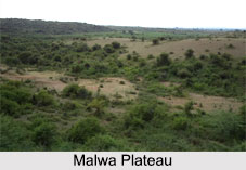
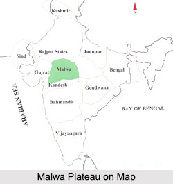
 Malwa Plateau is a region in west-central northern India occupying a plateau of volcanic origin in the western part of the state of Madhya Pradesh and south-eastern parts of Rajasthan. This region of plateau had been a separate political unit from the time of the Indian tribe of Malavas until 1947, when the British Malwa Agency was fused into Madhya Bharat, also known as Malwa Union. Although political borders have fluctuated throughout the history of Malwa Plateau, the region has developed its own distinctive culture and language.
Location of Malwa Plateau
Malwa Plateau primarily includes the state of Madhya Pradesh and its districts of Dewas, Dhar, Indore, Jhabua, Mandsaur, Neemuch, Rajgarh, Ratlam, Shajapur, Ujjain, and parts of Guna and Sehore, and the Rajasthan districts of Jhalawar and parts of Banswara and Chittorgarh. Malwa is surrounded in the northeast by the Hadoti region, in the northwest by the Mewar region, in the west by the Vagad region and Gujarat. Politically and administratively, the definition of Malwa Plateau is sometimes extended to include the Nimar region south of the Vindhyas.
History of Malwa Plateau
The name Malwa is derived from "Malaw" which means Goddess Lakshmi. Historically, this plateau has been under the rule of Mauryas, Guptas and Paramara dynasties. It came under the control of the Muslims in 1390 and was handed over to the British in 1817 from the Marathas. The first significant kingdom in Malwa Plateau was Avanti, an important power in western India in around 500 BC, when the Maurya Empire invaded it. The 5th Century Gupta period was a golden age in the history of Malwa. In 756 AD Gurjara-Pratiharas advanced into Malwa. In 786 the region was captured by the Rashtrakuta kings of the Deccan.
Dilawar Khan started the Malwa Sultanate and established a capital at Mandu. The Muslim sultans invited the Rajputs to settle in the region but soon sought help from the rulers of Gujarat to subside the growing power of the Rajputs. After the defeat of Rajput confederation against Babur in the Battle of Khanwa, the region came under Mughal rule. As the Mughals weakened after 1700, the Maratha army under Baji Rao I invaded Malwa in 1698. In 1724, Malharrao Holkar became the leader of Maratha armies in Malwa and in 1733 the Maratha Peshwa granted him control of the region. Another Maratha general, Anand Rao Pawar, established himself as the Raja of Dhar in 1742, and the two Pawar brothers became Rajas of Dewas State.
During the 18th century, Malwa, under the rule of the Holkar dynasty, saw the conflict between Marathas and the Pindaris, the irregular plunderers. The Pindaris were backed by the British general Lord Hastings. This conflict eventually led to the defeat of the Marathas and the region was captured by the British in the Third Anglo-Maratha War. The Holkars of Indore became a princely state of the British Raj and in 1818 the Malwa Agency became a division of Central India. After the independence of India in 1947, the Holkars acceded to India, and most of Malwa became part of the new state of Madhya Bharat, which in 1956 merged into Madhya Pradesh.
Geology of Malwa Plateau
The geology of Malwa Plateau generally refers to the volcanic upland south of the Vindhyas, which includes the Malwa region and expands in east to include the upper basin of the Betwa and the headwaters of the Dhasan and Ken rivers. The Chambal River and its tributaries drain most of the Malwa Plateau. The upper reaches of the Mahi River drain the western part of this Malwa Plateau. The average elevation of the Malwa plateau is 500 metres, and the landscape slopes towards the north. Malwa Plateau experiences a tropical climate with dry deciduous forests.

Economy of Malwa Plateau
Ujjain was the political, economic and cultural capital of the Malwa Plateau in ancient times, and Indore is presently the largest city and commercial center. Overall, agriculture is the main occupation of the people of Malwa Plateau. The region has been one of the important producers of opium in the entire world. Cotton and soybeans are other important cash crops of Malwa Plateau and textiles are a major industry.
Culture of Malwa Plateau
Malwa Plateau is home to a number of tribes, most prominent of them being the Bhils. The culture of Malwa Plateau had influences from Gujarati, Rajasthani and Marathi cultures. Malvi is the most commonly used language, especially in rural areas, while Hindi is widely understood in cities. The place is famous for the rituals called Hajri to cure mental illness.
The region boasts some world prominent leaders in the arts and sciences, including the poet and dramatist Kalidasa, the author Bhartrihari, the mathematicians and astronomers Varahamihira and Brahmagupta, and the polymath King Bhoja.
Languages Spoken in Malwa Plateau
There is a sizeable Marathi community in the Malwa region who speak Marathi. A significant number of Marwaris, Jats, Sindhis, and Rajputs also live in the region. Malwa region is also inhabited by Jains, Goan Catholics, Anglo-Indians, Punjabis, and Parsis or Zoroastrians. Each community speaks in its mother tongue which means Malwa plateau has a diverse linguistic culture.
Tourism in Malwa Plateau
Tourism in the Malwa plateau comprises of historical and religious spots like monuments and temples. Major places of tourist interest in Malwa Plateau include Ujjain, Mandu, Maheshwar and Indore. The abandoned Lat Masjid and the tomb of Kamal Maula, a Muslim saint are other places of interest. The shrine of Hussain Tekri, built by the Nawab of Jaora, Mohammad Iftikhar Ali Khan Bahadur during in the 19th century is also visited by thousands of devotees throughout the year. Hazrat Imam Hussain is another famous religious place visited by people during the month of Muharram. Mandu valley and Maheshwar Fort are two prominent tourist attractions in Malwa Plateau.


