 Islands of Mumbai Harbour mainly cater to the naval centres and also provide oil resources to certain extent. Mumbai Harbour is also known as the Front Bay in the southern portion of the Ulhas River estuary. The northern and narrower part of this Ulhas River estuary is called Thane Creek.
Different Islands of Mumbai Harbour
Following are the different Islands of Mumbai Harbour:
Butcher Island: Butcher Island is also known as Jawahar Dweep. It is used as an oil terminal by the Mumbai harbour. It has jetties for tankers and various other infrastructures for offloading the unfinished oil and for loading superior petroleum merchandises. The island is limited to port employees, and not open to the public.
Elephanta Island: The historical island of Elephanta is one of the six islands lying in the harbour. It is also known as Gharapuri Island and is the famous of the islands in Mumbai Harbour. The Elephanta Caves located on the island are a UNESCO World Heritage Site. The group of five larger caves have elaborate Hindu religious rock sculptures. Two smaller caves have Buddhist religious sculptures. The carvings dated back to between 5th and 8th centuries.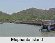
Cross Island: It is a small, deserted islet just off the coast of the Dockyard Road. The island is bearing the ruins of a fort located about 400 metres from Ferry Wharf on the east coast of Mumbai. The island is locally identified as Chinal Tekdi. The island is host to an oil refinery and numerous large gas holders.
Middle Ground Island: It is a small island in the Thane creek. It features a historic coastal gun battery of the Indian Navy. The island is actually a piece of hard basalt rock, rising out of the creek bed, laying a few hundred square metres in area. It belongs to the Indian Navy. The island serves as the saluting base to the Commander-in-Chief of the Western Naval Command. Oyster Rock is part of the group of islands of Mumbai Harbour in the state of Maharashtra. Since the navy conducts its exercises and experiments in and around this island, tourists are advised to keep well clear of it.
Oyster Rock Island: It is a small group of rock outcroppings in the harbour. The area has limited access since it is used for naval exercises. The island was used as a naval museum earlier.
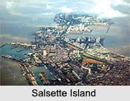
Salsette Island: It is the large island on which the cities of Mumbai and Thane are situated. It is separated from the Konkan mainland by the Vasai creek and the Ulhas River and is the 14th most populous island in the world. Mumbai was originally a distinct island from Thane, but renovation of land has long since merged the islands. Powai Lake, Tulsi Lake and Vihar Lake are the largest lakes on the island.
Visiting Information of Mumbai Harbour
Mumbai is the nearest city, which is about 10 kilometres from the island city. A ferry can be availed from Mumbai. Boats leave daily from the Gateway of India, taking about two hours for the journey to the island and back. The inhabitants of the islands of Mumbai Harbour are very few and live by way of fishing and boat repairing.