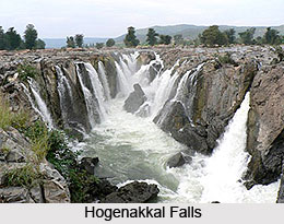
 The River Kaveri enters the Indian state of Tamil Nadu through Krishnagiri district and along its course structure many gorges and waterfalls; among them the most famous is the Hogenakkal falls in Dharmapuri District. The three minor tributaries of River Kaveri, flowing in this state are Palar, Chennar and Thoppar above Stanley Reservoir in Mettur , where the dam has been constructed. The Mettur dam joins the Sita and Pala mountains standing beyond that valley across which the Kaveri River flows, up to the Grand Anicut. The dam in Mettur holds water not only for the purpose of irrigation but also to ensure the regular and ample supply of water to the important Hydroelectric generating station at Mettur.
The river then runs through Erode district where river Bhavani merges with it. While passing through Erode, two more tributaries merge. Noyyal and Amaravati join this before it reaches Thiruchirappalli district. In this region, the river becomes much wide, with a sandy bed, and then flows in an eastern direction until it divides into two at upper anicut at about 14 kilometres west of Thiruchirappalli. The northern branch of river is named the Coleroon or Kollidam and the southern branch has the same name Kaveri and then goes eastwards directly entering the Thanjavur District. These two rivers again join and form the Srirangam Island near Thiruchirappalli.
As the Chola king, "Karikalan" constructed the bank for the Kaveri all the way from Puhar (Kaveripoompattinam) to Srirangam, he was immortalised. The bank was built almost 1,600 years ago or may be earlier. On either sides of the river walls are found spreading to a distance of around 1,080 feet. The dam Kallanai constructed by him on the border between Tiruchirapalli and Thanjavur is a superb art of engineering, the ingredients of the wall was earth and stone and has borne the disasters of nature for hundreds of years.
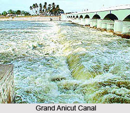 In 19th century, the dam was renovated on a bigger scale. The name of this historical dam has since been changed to "Grand Anicut" and is known to be as the head of a great irrigation system in the Thanjavur district. From this point, the Coleroon or kollidam runs in the direction of northeast and empties itself into the sea at Devakottai, a little south of Parangipettai. From river Manniar, Coleroon and Uppanai divide at lower Anicut and irrigate a particular area of Mayiladuthurai taluk and Sirkazhi taluk in Thanjavur District. After Grand Anicut, the Kaveri divides into numerous branches, covers the whole of the delta with a vast network of irrigation channels, and gets lost in the wide expanse of paddy fields.
The mighty Kaveri river in Tamil Nadu is reduced to a number of unused channels and falls into the Bay of Bengal at the historical place of Poompuhar or Kaveripoompatinam about 13 km north of Tharangampadi. The river Kaveri flows in most of the districts of Tamil Nadu, namely Thanjavur, Thiruvarur and Nagapattinam in different names by its tributaries and branches viz., Grand Anicut canal, Adapparu, Arasalaru, Harichandranathi, Ayyanaru, Kaduvaiyar, Cholasudamani, Kirtimanar, Kattar, Kodamuritiyar, Mahimalayaru, Koraiyar, Mudikondan Aru, Majalaru, Mullaiyaru, Nandalaru, Nattaru, Noolaru, Odambogiyaru, Palavaru, Pamaniyaru, Pandavaiyaru, Pannaiyaru, Putharu, Vadavaru, Valapparu, Thirumalairajanaru, Valavaikkal Aru, Vanjiaru, Veerasozhanaru, Vellaiyaru, Vennaru, Vettaru, Vikaraman Aru and all these branch off into a number of small streams.