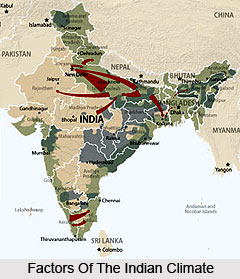
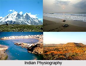
 It is true that the determiners of climate go much further than man-made political boundaries. Several of the factors and phenomena governing the climate of India overstep its four walls, i.e., (i) situation, (ii) relief, (iii) surface winds, and (iv) upper air circulation.
Locational and Relief Factors
Situated approximately between 8°N and 37°N latitudes, India is divided in nearly two equal parts by the Tropic of Cancer. It stretches east-west just half way through the country.
One can notice how India is flanked by Indian Ocean in the south and girded by a towering and incessant mountain wall in the north. Such a condensed physical setting imparts it an extensive common climatic framework. One can also note the abysmal arms of the Indian Ocean - the Arabian Sea and the Bay of Bengal. They exercise moderate influence on much of the Indian subcontinent. More significantly, they work as a storehouse of severely needed moisture to this water-thirsty landmass.
The mighty Himalaya along with its lengthinesses, work as a successful climatic divides. The looming mountain chain provides an indomitable defend to protect the subcontinent from the northern winds. These cold and icy winds initiate near the Arctic Circle and blows throughout Central and Eastern Asia. Thus the northern mountain wall is accountable for lending the whole of northern India a tropical touch. Comparatively high temperatures virtually throughout the year and principally dry winters- are the two characteristic facets of a topical climate. Excluding the fringe, the Indian subcontinent does demonstrate these two overriding characteristics.
The Surface Winds and Air Circulation
One can start by firstly looking at the world map of the pressure belts and planetary winds. It can there be noticed that India lies in the area of land bearing winds, initiating from the subtropical high pressure belts. On the whole they are moistureless winds, if not for the occurrence of the monsoons, India would have been a baked land or a desert. The subtropical high pressure belt of the northern hemisphere brings about everlasting winds. They blow in the direction of the equatorial low pressure belt. While travelling towards the south, they redirect towards the right i.e. to their west. Consequently they blow from north-east towards south-west. This is why these eternal winds are known as the north-east trade winds. The German word `trade` means `track` and represents `blowing steadily in the same direction and in a constant course`. India thus lies in the belt of the north-east trades, completely lacking in moisture. This is however only half story of the Indian climatic happening. The other half is yet to be described.

The air pressure does increase by stacking of air, coming down from above. But it is also a function of air temperature. The land and water bodies do not get heated precisely in a similar way. In summer the land gets more heated compared to the seas. Therefore a low pressure rises over the centre of the land masses. This occurrence is fundamentally responsible for the turnaround of wind direction, giving rise to the south-west monsoons.
Air currents vary from winds because they are located at a pretty high altitude from the earth`s surface. The motion of jet streams also touches on the climate of India. A jet stream blows rapidly in a tapered zone in the upper atmosphere. A westerly jet stream in lower stratosphere passes over south of the Himalaya during the winters. In June, it moves northwards to position itself north of the Tien Shan in Central Asia- instead, an easterly jet stream develops in approximately 25°N. Low pressure and freshly developed jet stream are accountable for the abrupt outburst of the monsoons in northern India. Cooling effect easterly jet stream causes rain from maritime clouds, previously lingering over this area. The unsteady equatorial oceanic air is able to form rain-bearing dark clouds, often up to an altitude of 9 to 15 km high up into the sky. This enlightens the happening of prevalent storms, thunders and great progress of monsoons all over India, often in just eight to ten days.
The Mechanism of Monsoons
The word monsoon, as is distinguished, has been deduced from an Arabic word `mausim` that factually means `season`. The word monsoon, hence, refers to a season in which the wind system is wholly overturned. The moist monsoon winds, after voyaging over the equator in the Indian Ocean, gains a southwesterly direction as the area attracted towards the low pressure are located in Northwest India and Central Myanmar. The dry and hot land-bearing trades are consequently entirely swapped by sea-bearing winds, full of moisture. Based on the dissimilarity between tropical continental air and equatorial maritime air, the meteorological definition of the monsoons is quite uncomplicated. According to them it is a total replacement of the dry hot air by the equatorial maritime air, up to an elevation of three to five kilometres over the land and water surface.
The occurrence of monsoons is certainly quite prehistoric, but its precise nature and cause are being observed only lately. The substantial breakthrough took place when it was studied at the global rather than regional level. On the whole this occurrence is limited to tropical lands, lying within 20°N and 20°S. But in the Indian subcontinent it is significantly regulated by the Himalayan ranges bringing the whole subcontinent under the control of these moist equatorial winds for a season varying between two to five months. It accounts for 75 to 90 per cent of the yearly rainfall, just from June to September.

The nature and system of the monsoons is understood with the help of meteorological statistics that are collected from stations on land, ships in oceans and from upper air. It was formerly assumed that monsoon was a phenomenon of surface winds. It is now known that upper air currents also play a substantial role in the mechanism of monsoon.
It has also been established that the concentration of monsoons can be largely forecast by measuring the differentiation in pressure between Tahiti (roughly 18°S and 149°W) in French Polynesia in east Pacific and Port Darwin (12°30`S and 131"E) in Northern Territory of Australia in Indian Ocean, southeast of Indonesia.


