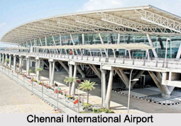
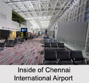
 Chennai International Airport is the fourth busiest airport in India, in terms of total passenger traffic after airports at Delhi, Mumbai and Bengaluru. It is the 49th busiest airport in Asia. It is an international airport serving the city of Chennai, Tamil Nadu, India and its urban region. It is located about 15 kilometres southwest of the city centre. It was one of the first airports of India and served Air India flights from Mumbai during the 1950s.
The airport is owned by the Government of India and is operated by the Airports Authority of India. It is considered as the main air centre of south India. It was the first airport in India to have international and domestic terminals located adjacent to each other. This airport serves as the regional headquarters of the Airports Authority of India for South India.
History of Chennai International Airport
Chennai International Airport is one of the primary airports in India. It was the last destination of Air India`s first flight from Mumbai via Belgaum in 1954. The airport was built on a land, donated by the past governor of Madras Presidency, Kamalumpundi Sriramulu Naidu. The first plane "de Havilland" landed in Chennai Airport in 1932. The usage was detained only to military operations in World War II. The Civil Aviation Department took over its operations in 1952, followed by the International Airport Authority of India in 1972.
 In 1988, Anna terminal was added to the pre existing Kamaraj terminal. The new domestic terminal was commissioned in 1985 and the international terminal was commissioned in 1989. The new international departure terminal was commissioned in 2003. Chennai Airport became the first international airport in the country to receive ISO 9001-2000 certification in 200. In 2008, the Airport Authority of India started major modernisation of the airport.
Structure of Chennai International Airport
Chennai International Airport consists of three terminals; the old terminal at Meenambakkam which is used for cargo, while the new passenger terminal complex is at Tirusulam which is used for passenger operations. The passenger terminal complex includes the domestic and international terminals interconnected by the administrative offices. The international terminal was expanded further south recently by adding a new block with three aero-bridges. At present, the new international block, Terminal 4 is used for departures while the older building, Terminal 3 is used for arrivals.
The Anna international terminal has 6 boarding gates on the first floor. The Kamaraj domestic terminal has a total of 9 boarding gates, including 6 on the ground floor and 3 on the first floor. The airport has 24 taxiways, including the 411-metre-long taxiway. It is capable of handling 36 aircraft movements per hour. It has 70 parking bays currently, one of which can have room for the super-jumbo Airbus A380. Chennai airport is the first airport in India to have aero-bridges at the domestic terminal.
Airlines of Chennai International Airport
The airport serves as the regional headquarters of the Airports Authority of India for the southern region of India comprising the states of Tamil Nadu, Andhra Pradesh, Telangana, Karnataka, and Kerala and the union territories of Puducherry and Lakshadweep. Some of the popular airlines of the airport are AirAsia, Air India, Alliance Air, British Airways, Emirates, Flydubai, IndiGo, Kuwait Airways, Malaysia Airlines, Qatar Airways, Thai AirAsia, Vistara etc.
Visiting Information of Chennai International Airport
The airport is situated on the Grand Southern Trunk Road and is served by Tirusulam railway station on the Suburban railway network. The airport metro station of the Chennai Metro connects the airport to other parts of the city.


