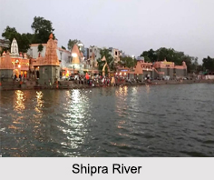
 Shipra River, also spelt as "Kshipra" is a river that flows in the state of Madhya Pradesh. It is a perennial river and is considered as sacred as the Ganga River by the Hindus. The main tributaries of Shipra are Khan and Gambhir.
Origin and Course of Shipra River
Shipra River originates in the Vindhya Range from a hill called Kakri-Tekdi which is in the north of Dhar situated at a distance of 11km from Ujjain. This river is 195km long, out of which 93km flow through Ujjain. It then flows in the south direction and touches Ratlam and Mandsaur across the Malwa plateau to join the Chambal River.
Legend of Shipra River
Legend has it that once Lord Shiva went begging for alms, using the skull of Lord Brahma as the begging bowl. Nowhere in the three worlds did he manage to get any alms. Ultimately, he went to Vaikunth, the abode of Lord Vishnu and asked Lord Vishnu for alms. In return, Lord Vishnu showed Lord Shiva his index finger, which enraged the latter. Lord Shiva took out his trishul and cut Lord Vishnu"s fingers. Vishnu"s fingers began to bleed profusely and the blood accumulated in Brahma"s skull and soon overflowed from it. The flow became a stream and finally a river - "Shipra".
 The Puranas or ancient Hindu texts also put forward that the Shipra originated from the heart of Varaha, Lord Vishnu"s incarnation as a boar. Also on the banks of the Shipra River is Sage Sandipani"s ashram where Krishna had studied.
Religious Significance of Shipra River
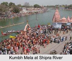
The holy city of Ujjain is located on the right bank of the Shipra River. The famous Kumbha Mela takes place in the ghats of this city, once every 12 years, a yearly celebration of the river Goddess Kshipra. There are hundreds of Hindu shrines along the banks of the Shipra River.
The most popular ghat of Shipra River is "Ram Ghat". Ram Ghat is the most ancient ghat of the Shipra River. During the Kumbh Mela, people use this ghat for bathing as they believe it is the sanctified ghat of the river. Ram Ghat has a vital importance in the history of Shipra River and Ujjain city.
Thus, Shipra River is one of the sacred rivers in India. It finds mention not only in ancient Hindu texts, but also in Buddhist and Jain scriptures. Every evening "Shipra Aarti", the offering of lit oil lamps to the river takes place. Thousands of small lamps are set afloat on the river on rafts of leaves and flowers. It is believed that the north-bound Shipra takes these offerings to the abode of Lord Shiva in the Himalayas.
Devotees come here with the belief that a dip in the river washes away their sins. All pilgrims take a ritual dip in the river before heading to Sabarimala. Pilgrims also perform "pitru tarpanam" (offering to ancestors) before starting the trek to the shrine. People also come here to perform funeral rites for the departed souls.
Ecological Significance of Shipra River
The Shipra River is home to a variety of fishes. A 10 km stretch of the Shipra River, where the fish congregate for breeding is declared as a sanctuary. Earlier there used to be plenty of water in the river. Now the river has stopped flowing since a couple of months after the monsoon.


