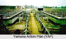
 Yamuna River is a chief tributary to the holy river Ganga. However, river Yamuna itself is considered as one of the holiest rivers of India and is used by millions of people as a source for drinking water besides for bathing and irrigation. In recent years, it has become heavily polluted due to various reasons that are also affecting human health and bio-diversity of the eco-system.
One of the main reasons of pollution of the river is discharge of unprocessed domestic wastewater and other wastes into the river from the towns located along its banks. To arrest river pollution, certain measures of cleaning river have been taken by the Ministry of Environment and Forests (MoEF) of the Government of India (GOI) in 12 towns of Haryana, 8 towns of Uttar Pradesh, and Delhi under an action plan. The National River Conservation Directorate (NRCD) of the Ministry of Environment and Forests is implementing the Yamuna Action Plan or YAP since 1993. The Japan Bank for International Cooperation (JBIC) is an active participant in the Yamuna Action Plan in 15 of the above 21 towns, excluding 6 towns of Haryana included later on the direction of the honorable Supreme Court of India with soft loan backing of 17.773 billion Japanese Yen, which is equivalent to about Rs. 700 crore INR, while GOI is providing the funds for the remaining 6 towns were added later.
At the request of GOI, Government of Japan was ready for the extension of the validity period of the loan by two years. The expiry date of the loan is now at April 19, 2002. During the extended period, the processing works will be completed along with some remedial works to increase the effectiveness of the project.
The primary schemes designed under Yamuna Action Plan are as follows:
Sewerage Component
• Interception and Diversion Works include Intermediate Pumping Stations
• Main Pumping Station and Rising-Mains
• Sewage Treatment Plant or STP
Non Sewerage Component
• Low Cost Sanitation or LCS.
• Improved wood based & Electric Crematoria.
• Plantation
• Public Participation
• Bathing ghats / River front Developments
The Uttar Pradesh Jal Nigam (UPJN) in U.P, Haryana Public Health Engineering Department (HPHED) in Haryana, Delhi Jal Board (DJB) and Municipal Corporation of Delhi (MCD) in Delhi are implementing all these works under the coordination of National River Conservation Directorate (NRCD). The TEC-DCL Consortium or the Indo-Japanese consultants have been appointed as project consultants to supervise the progress of the schemes on everyday basis.


