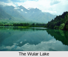
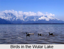
 Wular or Wullar Lake is located in the Bandipora district of Jammu and Kashmir in India. It comes under the category of freshwater lakes in India. It is the largest freshwater lake in India. In fact, it is one of the largest freshwater lakes in Asia. This balloon shaped lake has the potential to spread over nearly 200-sq-kms, but it is also interesting to note that the actual surface area of the lake varies seasonally from 12 to 100 square miles (30 to 260 square kilometers). Another interesting fact about this lake is that Mota Khon- the `Gulf of Corpses` is the deepest section of the Wular Lake that is believed to swallow all the dead bodies in the lake. This lake is famous as a picnic spot.
Etymology of the Wular Lake
According to the Nilamata Purana, the Walur Lake was known as `Mahapadmasaras`, which is a Sanskrit word. Mahapadamsar was referred to as Bolor by Al-Biruni (960-1031 AD). The high rising waves in the lake, during the afternoons, are called Ullola in Sanskrit, meaning stormy leaping of the waves. This phenomenon is possible because of big dimensions and extent of water in the lake. From Bolor, its name was further corrupted to Wular. It is also believed that the name Walur originated from the Kashmiri word `Wul`, which means a gap or a fissure.
Geography and Hydrography of the Wular Lake
The Wular Lake has a maximum length of about 16 kms, breadth of about 7.6 kms and an average depth of about 5.8m. The lake basin was formed as a result of tectonic activity. The north and east of the lake is beautified by high mountain ranges, more specifically, fairly dense coniferous forests and pastures. River Jhelum drains its water in this lake, 40-km downstream from Srinagar, and then flows out again. The Wular is directly fed by two important streams of Erin and Madhumati.
Terrestrial birds are noticed around the lake. Some of them are- Indian roller, Eurasian sparrow hawk, hoopoe, chukar partridge, black-eared kite, koklass pheasant, rock dove, barn swallow and golden oriole.
 Some of the fishes in this lake are- common carp (cyprinus carpio), rosy barb (barbus conchonius), nemacheilus species, crossocheilus latius and various snowtrout species in the genera schizopyge and schizothorax.
The fishermen primarily hunt for the endemic schizothorax species and the non-native carp. Their catch comprises of about 60 percent of the total yield of fish in Kashmir. People around this lake also harvest plants such as the grass- phragmites and waterlily- nymphoides for animal fodder.
Biological, Hydrological and Socio-Economic Values of the Wular Lake
The Wular Lake acts as a blessing for the people living in the Kashmir Valley. It functions to maintain the hydrographic system of this valley. It prevents flooding in this area, by absorbing the annual flood water in huge amount. Marshes surrounding this lake act as a natural habitat for wildlife. It is also an important fish resource in the state. It supports the livelihood of human beings living along its fringes. Therefore, in 1986, the Ministry of Environment and Forests under the Government of India, declared this lake as a wetland of national importance under its wetlands programme. This lake was promoted as a wetland of international importance, after being declared as a Ramsar Site in 1990.
Zaina Lanka Island in the Walur Lake
The Zaina Lanka Island is an artificial island known to be constructed in the 15th century following the orders of King Zain-ul-abidin. This island was built amidst the lake with the aim to shelter boatmen during heavy rainfall and storms. Today, only its remains exist in the lake.
Ecological Crisis faced by the Wular Lake
Various uncontrolled activities are responsible for deteriorating the quality of this lake. Large parts of the lake`s catchment areas have been converted into agricultural land. Chemical fertilizers and animal wastes have been released into the lake, without any prohibition. There has also been uncontrolled hunting of waterfowls and migratory birds of this lake. Weed infestation in the lake is also responsible for creating the ecological crisis.
Restoration of the Wular Lake
To alleviate the above mentioned problems, this lake has been listed among the 26 Indian wetlands chosen for conservation and sustainable utilization and is designated as a Ramsar site. Under the National Lake Conservation Programme, it was planned that 2 million trees will be cut to restore the Wular Lake. The Environment Ministry of India took a step forward and approved Rs.4 billion for the restoration project. The partner organization South Asian Voluntary Association of Environmentalists (SAVE) is a joint initiative of individuals with the aim to protect the ecology and to conserve the Wular Lake.
Tulbul Project Associated with the Restoration of the Wular Lake
The Tulbul Project commenced with the objective to regulate the release of water from the natural storage in the lake to maintain a minimum draught of 4.5 feet (1.4 m) in the river up to Baramulla during the lean winter months. This project was conceived in the early 1980"s and the execution of the project began in 1984, to build a "navigation lock-cum-control structure" at the mouth of Wular Lake. The barrage was planned to be 439 feet (134 m) long and 40 feet (12 m) wide, and would have a maximum storage capacity of 300,000 acre feet (370,000,000 m3) of water.
Unfortunately, since 1987, the dispute between India and Pakistan over the Tulbul Project has suspended the construction of the barrage. Pakistan objected this project due to the violation of the 1960 Indus Waters Treaty. India analyzed that to sustain navigation throughout the year in the river Jhelum, a minimum depth of water is needed. India thus pressed on the execution of the Tulbul Project. India also highlighted that it would affect the interests of the people of Jammu and Kashmir and the people of Pakistan would be deprived of irrigation and power benefits. But Pakistan remained adamant, due to the violation of the treaty.
Wular Lake"s Support to Tourism
To exploit Wular Lake"s potential for tourism, boating and water sports like water skiing and water rafting, have recently been launched by the Government of India Tourism in collaboration with Kerala Tourism and Jammu and Kashmir Tourism. The contract for the operation of the site for the above mentioned purpose was awarded in September 2011.
Visiting Information
The Wullar Lake is located near about 50-km from Srinagar, one of the capital cities of Jammu and Kashmir. On a visit to this lake, buses are available from Srinagar. Early morning visit to this lake from June to August is generally considered the best time to experience the beauty of this lake.


