West Jaintia Hills District belongs to the district of the Jaintia Hills which is located in the Eastern Indian state of Meghalaya. The district headquarters of this region of India is in Jowai and it occupies a total area which measures about 3,819 square kilometer.
 Mythological History of West Jaintia Hills
West Jaintia Hills District was known as `Ka Ri Khadar Doloi` or the land of twelve tribal chiefs. Villages were referred to as provinces or `Elaka` and the head of the village, or the `chief` was revered as the `Doloi`. The village Doloi used to perform all the traditional rites and rituals but today there have been certain modifications in the role of the Doloi. The Doloi enjoyed similar position in the administration of the village, as that of a king or `rajah`. He presided over his very own `durbar`, just resembling that of a royal king. Syiem Durbar, Elaka Durbar was some of the durbars. Durbars were conducted to supervise the activities and duties of the government. As many as twelve Dolois used to rule over the region of the West Jaintia Hills District.
Initially, the Dolois used to follow the simple doctrines of peace and love, but later resorted to violence on account of an abrupt rise in population. Concerned over the growing level of unrest amongst themselves, the twelve Dolois met at a round table conference at Nartiang. In that conference, they decided to appoint a single ruler or Doloi which would enable the retainment of unity in the kingdom. However, it was also discussed that the king would have no ownership rights and even his soldiers would be offered by the Dolois. He would not enjoy the right to impose taxes on his subjects. However, the king would be entitled to the right of printing his individual currency by his name, and this currency would obtain the legal tender. The king was empowered to collect taxes from the inhabitants of other kingdoms which were defeated by West Jaintia Hills.
During battles, the king was entrusted the duty of protecting his people and lead his personal army. Despite the presence of the king, the twelve Dolois maintained that they would continue to control their individual Elakas. In case of conflicts or disputes, the king would be consulted and his rules would be revered and followed by all and sundry. Therefore, just after the conclusion of the conference, the Dolois started seeking their king. As per a popular legend, the Doloi of the area called Nartiang was told that there was a man who resided in Sutnga village named as U Loh Ryndi Pala who lived together with a lady known as Ka Lidakha who was believed to have been a fish before she transformed into a human being.
U Loh Ryndi Pala possessed three sons and two daughters. The Doloi of Nartiang, U Kongsan, asserted that Ryndi Pala was the ideal ruler of their kingdom. This was a unanimous decision and U Kongsan was sent to Sutnga village, along with other Dolois. Thereafter, one of the three daughters of U Loh Ryndi Pala, who was named Ka Rupanga, was proposed to be the Queen Mother of her son, who was offered the prestigious title of a king. The son of Ka Rupang was aged 14 and appointed as the `Iakor Sing` or king. There was another rule which said that if the subjects were dissatisfied with the services of the Doloi, then the local priest or `Lyngdoh` had the right to remove the Doloi from his post. These accounts are completely based on oral legends which were passed from one generation to the next.
Following the annexation of the West Jaintia Hills District by the British, the `Syiem` system was removed. But, `Doloi` and `Waheh Chnong`, the other important institutions were retained by them. The British ruled these regions, after uniting some villages of Khasi Hills with the entire portion of Jaintia Hills. These areas of India was categorized under `British areas` and were administered by the British government.
 Geography of West Jaintia Hills District
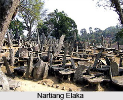
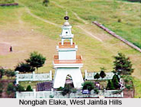
The geography of West Jaintia Hills comprise various areas or `Elaka` like `Nartiang Elaka`, `Raliang Elaka`, `Shangpung Elaka`, `Jowai Elaka`, `Lakadong Elaka`, `Mynso Elaka`, `Sutnga Elaka`, `Nongtalang Elaka`, `Nongbah Elaka` and others. The largest population in the West Jaintia Hills is present in the Nartiang Elaka.
People of West Jaintia Hills District
The local residents of West Jaintia Hills are believed to be the descendants of the race of Indo-Mongoloid. Austric language is the main language used by the people. Historical records claim that the origin of the people of West Jaintia hills District is linked to a race who had settled in large areas of South-China, Burma, Indo-China and northern portions of India. Scheduled Tribe constitutes about 2, 10, 558, while Scheduled Caste represent about 747 of the total population of the West Jaintia hills District. Pnar is the most common language which is utilized by the regional people of West Jaintia Hills District. Khasi language is also employed at times, especially for educational purposes. In schools, English is the most preferred language or medium of communication. Outsiders staying here also converse in languages like Bengali , Nepali, Assamese and Hindi.
Culture of West Jaintia Hills District
The local culture of West Jaintia Hills District reflects their unique traditions and culture. `Niamtre` is the name of their religion. Inhabitants of Jaintia Hills have embraced Christianity, ever since the arrival of British Raj in the nation in the 17th century. Unitarians and Muslims are the other groups of people who reside in West Jaintia Hills. The education, economy, traditions, and lifestyle of the regional people of West Jaintia Hills are a reflection of their beautiful culture which was influenced by Welsh Missionaries. If someone dies in a village, people cease their chores and pay a visit to the house of the deceased as a marl of respect towards the departed soul.
Administration of West Jaintia Hills District
The head of the District administration is the Deputy Commissioner, who is the head of the judiciary and also the head of the executive in the district. Additional Deputy Commissioner, Extra Assistant Commissioners, Sub-Divisional Officers of Sub-Divisions are the officers who assist the Deputy Commissioner in his functions. Deputy Commissioners have been entrusted the duty of interacting with the developmental heads of West Jaintia for activities like MLA`S Scheme, employment assurance schemes and others.
Funds are calculated and released for the purposes of development of the district by the District Planning Officer. The District Rural Development Board or DRDA, as well as the Deputy Commissioner is the chairman of this agency. Schemes concerning rural development are arranged by Block Development Officers. The official supervisor of this agency is the Project Director.
The Deputy Commissioner also serves as the District Magistrate for ensuring law and order in the West Jaintia Hills. Sub-Division Magistrates, Additional Deputy Commissioner and some other officers like Executive Magistrates aide the District Magistrate in the disposal of his duties. The police administration of the district is looked after by the Superintendent of Police. In matters of revenue, the Additional Deputy Commissioner assists the Deputy Commissioner, along with the Revenue and Enforcement officials.
Natural disasters like cyclones, earthquakes, floods, violent storms are managed by the Deputy Commissioner. Assistance in the form of cash or kind is extended towards the victims of such natural calamities, by the Deputy Commissioner. Apart from this, the Deputy Commissioner is also known to be appointed for the post of Chairman of different institutions like colleges, banks, schools and many more.


