 West Garo Hills District is located in the westernmost part of Meghalaya. The district headquarters of West Garo Hills is Tura, which is the second largest town in the state after Shillong. West Garo Hills District is one of the largest districts of Meghalaya. Garo Hills District was divided into two districts, namely West Garo Hills District and East Garo Hills District in October 1976. The erstwhile West Garo Hills District was further divided into two administrative districts of West and South Garo Hills districts on June 1992. Total area occupied by West Garo Hills District is 3714 sq kms.
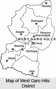
Location of West Garo Hills District
West Garo Hills District is situated approximately between the latitudes 90 degree 30 minutes and 89 degree 40 minutes east, and the longitudes of 26 degree and 25 degree 20 minutes north. West Garo Hills District is bounded by East Garo Hills District on the east, by South Garo Hills on the south-east, by Goalpara District of Assam on the north and north-west and by Bangladesh on the south.
Geography of West Garo Hills District
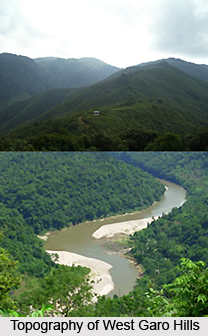
This region is mostly hilly with few plain lands in the northern and western zones. Topography of West Garo Hills District includes dense tropical forests and several rivers. One of the most significant mountain ranges of West Garo Hills District is the Tura range. It is around 50 kms long. Climate of West Garo Hills District is characterized with high temperature and it is influenced by the south-west monsoon. Diverse range of flora and fauna are found in the dense tropical forests of West Garo Hills District.
 Demography of West Garo Hills District
As per 2001 Census, total population of West Garo Hills District is 5,18,390, majority is rural population that is near about 4,59,412 and urban population is 58,978. The population of West Garo Hills District is pre-dominantly inhabited by Garo tribe, a tribe with a matrilineal society belonging to the Bodo family of the Tibeto-Burman race tribes. Other indigenous inhabitants are the Hajongs, Rabha tribe, Koch tribe, Rajbansis, Meches, Kachari and Dalus. The district is also inhabited by Bengalis, Assamese, Nepalese, Marwaries, Biharis and people from other parts of India.
Administration of West Garo Hills District
Administration of West Garo Hills District is under the in-charge of Deputy Commissioner. In West Garo Hills, there are two Additional Deputy Commissioners and four Extra Assistant Commissioners. The Deputy Commissioner`s office is divided into a number of important branches. These branches are the General or Establishment Branch, the Judicial Branch, the Registration Branch and other branches in charge of Supply, Housing, Elections, Block Development as well as the District Selection Committee. Garo Hills District Council came into being in the year 1952 under the provisions of the Sixth Schedule of the Constitution of India. In domestic matters, wide powers are exercised by the Nokma of individual villages. He is the head or chief of the dominant clan within the territorial limits. There are Laskars and Sardars recognized by District Council who have a certain measure of magisterial powers. West Garo Hills District comprises eight Community and Rural Development Blocks namely Rongram Development Block, Dadenggre Development Block, Dalu Development Block, Betasing Development Block, Selsella Development Block, Tikrikilla Development Block, Zikzak Development Block and Gambegre Development Block.
Education in West Garo Hills District
There are several degree colleges in West Garo Hills District. There is also a Law College and a College of Teacher`s Education (B.Ed College) at Tura. Moreover, there are higher secondary schools, secondary schools, upper primary and primary schools in almost all the villages of the district. At Tura, there is a campus of North-Eastern Hill University. Indira Gandhi National Open University (IGNOU) also has a study centre at Tura, which imparts distant education in different courses.
Economy of West Garo Hills District
Economy of West Garo Hills District is based on agriculture. Most of the people of the district are engaged in agriculture. Poultry and diary farming and bee-keeping are also practiced. Incentives provided for cash crops and efforts made to popularize terrace cultivation have yielded some results. Communication problems, soil erosion and loss of fertility are, however, among the problems retarding prosperous economic growth of the district. Since independence, various schemes have been adopted by the central and local governments for economic development.
 Tourism in West Garo Hills District
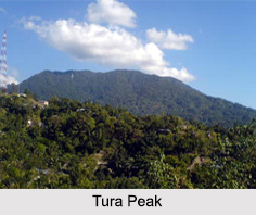
There are several tourist attractions in West Garo Hills District. Visiting this district of Meghalaya will mean a wonderful experience for the travellers. Some of the major attractions of West Garo Hills District are Tura Peak, Bhaitbari, Kata Beel, Darga of Hazrat Shah Kamal Baba, Nokrek, Arbella Peak, Sasatgre and Asanangre. The scenic beauty of the region enhances the charm of tourism experience of the visitors.
West Garo Hills District has several Health Centres and Dispensaries. West Garo Hills District is considered as nature`s wonderland, blessed with beautiful hills, rivers, streams, water falls, forests and a wide variety of flora and fauna.


