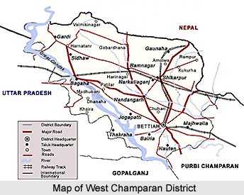
 West Champaran District is one of the 38 administrative districts of Bihar. Bettiah is the district headquarters. West Champaran District is located between 26 degree 16 minutes and 27 degree 31 minutes north latitude and 83 degree 50 minutes and 85 degree 18 minutes east longitude. This district is bounded by the hilly region of Nepal in the north, by Gopalganj District and part of East Champaran District in the south, by East Champaran District in its east and by Padrauna District and Deoria District of Uttar Pradesh. Total area of West Champaran District is 5228 sq kms.
History of West Champaran District
According to historical accounts, West Champaran District was formed out of Champaran District in 1972. Initially, West Champaran District was a sub-division of Saran District and then Champaran District. Old district of Champaran is a disintegrated version of Champaka aranya, as this region was a forest tract in the past.
Geography of West Champaran District
The district is categorized into hilly tract of Sumeswar and Dun range. Next to the hilly tracts is the terai region. The soil does not have any rocky formation and is cultivable. The hilly tracts of West Champaran District comprise vast stretches of forestlands. The climate of the district is cooler and damper than the adjoining districts. Winter starts usually in November and continues until February, it is followed by hot summer season when temperature reaches around 43 degree Celsius. Rains set in later parts of June.
Education in West Champaran District
West Champaran District has a literacy rate of 39.63 percent. There are a few schools in the district, which are amongst the best in North Bihar. Number of government primary schools in the district is 1340; number of Middle Schools is 284 and number of High Schools is 68 (including Minority and Project Schools), number of constituent colleges is 3 and there is one Industrial Training Institute.
Economy of West Champaran District
Agriculture is the main source of income of the people in West Champaran District. Some agro-based industries have flourished here and are being run successfully. Sugar mills are established at Majhaulia, Bagaha, Ramnagar, Narkatiaganj, Chanpatia and Lauria. Some rice mills are also being run successfully and the produce is being marketed to different places outside the district. Cottage industries based on local available natural and agricultural produce catering the local needs such as basket, rope, mat weaving etc. are also popular. Mainly three types of crops are produced in this district - Bhadai (autumn crop), Aghani (Kharif) and Rabbi (spring crop). Bhadai crops comprise mainly Maize and Sugarcane. The main crops of Aghani season are paddy, potato etc. Wheat, Barley and Arhar are main Rabi crops. Main crop of the low lying land in northern region of the district is paddy. This district depends a lot on livestock for cultivation.
Tourism in West Champaran District
Tourism in West Champaran District offers visits to some historical forts and religious places that also reflect the rich history of the region. . Tourism in West Champaran District comprises visits to various attractions like historical forts, archaeological remains and temples. People from all parts of the country come and explore the various tourism places offered by this district of Bihar. Some of the tourist attraction sites are Triveni Confluence, Bhitiharawa Ashram, Bawangarhi, Sumeswar, Nandangarh and Chankigarh, Ashoka Pillars, Bhiknatohari and many other spots that attract the tourist for the pilgrimage and nature tourism in this district.


