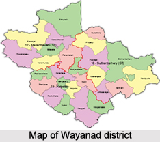
 Wayanad District is situated in the northeast of Kerala in south India. This district stands on the southern top of the Deccan plateau and its chief glory is the majestic Western Ghats with superior ridges placed with dense forest, tangled jungles and deep valleys, the landscape is uneven and often rough.
The strategic location of Wayanad District is in between the north latitude 110° 27` and 150° 58` and east 750° 47` and 700° 27`. Nilgiris and Mysore districts of Tamil Nadu and Karnataka, Coorg district of Karnataka, Malappuram, Kozhikode, and Kannur on its four sides, bound Wayanad District.
History of Wayanad District
The history of Wayanad District dates back to November 1, 1980, when it was carved out as the 12th district from Kozhikode and Kannur districts of Kerala. The history of the naming of this district is derived from two words Vayal and Naad, which means that Wayanad is Vayal i.e. paddy and Naad i.e. land. Thus became `Land of Paddy Fields`. There are many original tribes in this area. It is set supercilious on the majestic Western Ghats with altitudes ranging from 700 to 2100 Metres above mean sea level. The area of the Wayanad District is about 2132 sq. km. Wayanad District has three taluks, namely Mananthavady, Sulthan Bathery, and Vythiri. Some of the other important towns in this district are Sulthan Bathery and Mananthavady. The Wayanad District Panchayat office functions at Kalpetta near Civil Station.
Geography of Wayanad District
The geography of Wayanad District contributes to the soothing and comfortable climate in the region. The mean average rainfall in this district is 2322 mm. Some of areas in Wayanad district that experience heavy rainfall are Lakkidi, Vythiri and Meppadi. Annual rainfall in these high rainfall areas ranges from 3,000 to 4,000 mm. High velocity winds is common during the southwest monsoon and dry winds blow in during March-April. High altitude regions in this district experience severe cold. In Wayanad district the maximum average temperature is 29°C and the minimum temperature is 18°C respectively. This place experiences a high relative humidity, which goes even up to 95 percent during the southwest monsoon period. Generally, the year is classified into four seasons, namely, cold weather which lasts during December-February, hot weather which can be found during March-May, south west monsoon during June-September and north east monsoon during October-November.
River Kabani and its tributaries constitute a powerful river system in the landscape of Wayanad district. Panamaram rivulet or stream takes its origin from the perennial lake called, `Pookode Lake`. It flows swiftly through mountain ravines and joined by other streams, comes down into Panamaram valley, thus making it a spectacular view. This river, which is six kilometers away from Panamaram, joins with the Mananthavady rivulet. The later one originates from the lower regions of the peak `Thondarmudi`. From this junction onwards, the river is known as Kabani. It is Perennial River, which after entering Karnataka State it joins with the river Cauvery. The Kabani River and its tributaries, namely, Panamaram River, Mananthavady River and Thirunelli River, drain almost entire Wayanad district. 
This district has become a delightful tourist spot for thousands since the passing years for its breathtaking landscape and heritage spots. Other than thousands of people touring the place, Wayanad district is also a lucrative place for agricultural jobs and other related business.
Culture of Wayanad District
One of the important characteristics features of this Wayanad district is its large adivasi population. The tribal culture of this district is prevalent till this day. Some of them can be named mainly as Paniyas, Kurumas, Adiyars, Kurichyas, Ooralis, Kadans and Kattunaikkans. These are the different indigenous tribes of Wayanad. The Kurichyar is the most developed among them who are small landowners, whereas the members of other tribes are mostly labourers.
Demography of Wayanad District
Wayanad district has a large pioneer population. There are people from almost all parts of Kerala who migrated to this fertile land for building up their lives. Wayanad has a small Jain community consisting of Gowdras who came from Karnataka. They have built beautiful temples all over the district. Almost all sections of Christianity are well represented. Christians constitute one-fourth population of Wayanad while Muslims constitute another one-fourth population and rest of the population belongs to Hindus. Their hard work and sacrifice helped them to prosper. On the other hand, the last few decades have seen the complete social process of the original people.
Population of the district: According to 2001 Census, the population of this district is 7,80619 of which male population is 3,19,273 and female is 3,89,346. The population of Scheduled Tribes is 1,36,062 and that of Scheduled caste is 33,364. Population of Literacy in this district is 5,76,735 of which 3,03,579 belong to Males and 2,73,156 belong to females. Among the total population of 780619 numbers, 751007 persons live in rural areas while 29612 numbers live in urban areas.
Administration in Wayanad District
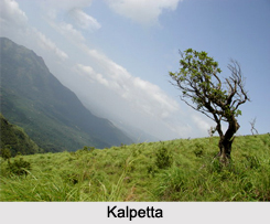
 Kalpetta is the headquarters of the Wayanad District Administration with Civil Station and other main offices. The district is divided in to three taluks, names, Sulthan Bathery, Vythiri and Mananthavady with an order to smooth running of the revenue administration. There are six firkas and 49 villages under these taluks. There is only one Revenue Divisional Office in this district that functioning at Mananthavady. The Wayanad District Panchayat office functions at Kalpetta near Civil Station. There are three Block Panchayats and 25 Grama Panchayats in this district. The block panchayats includes Sulthan Bathery, Kalpetta and Mananthavady while Kalpetta is the only Municipality in the district.
Agriculture in Wayanad district .
Agriculture is believed to be the predominant occupation in this district. The perennial crops and spices are commonly cultivated at this high altitude district. The major plantation crops include coffee, tea, pepper, cardamom and rubber. Coffee based farming system is a distinguishable feature of Wayanad district. Coffee is grown both as pure crop and as mixed crop along with pepper. The rice fields of Wayanad district are in the valleys formed by hillocks and in majority of paddy lands; only a single crop is harvested. Ginger cultivation in Wayanad district has also substantially increased in recent times and the crop here produced is mainly marketed in the form of green ginger. Home farming assumes importance in this district. The crops which are cultivated in this area include coconut, areca nut, pepper, vegetables, tuber crops, drumstick, papaya, etc. and fruit trees like mango and jack. The crop patterns or crop combinations prevailing in this district are not based on any scientific norms. For this a reason scientific cropping pattern suitable for the agro-ecological situation is to be recommended in this area.


