 Waithou Lake is one of the major lakes of Manipur which is about 16 km from the city of Imphal and is situated in the Thoubal district of Manipur. The Thoubal district is known for its many lakes and rivers with part of the famous Loktak Lake falling in the district. The lake lies in the northern part of the district and has been formed by the drained water getting collected that comes from the Waithou Hill and the many paddy fields on the west and east. The lake is filled with shallow perennial water body comprising three areas, namely Soirel, Cheksabi and Phumnom. The lake used to receive water mainly from the rivers which drain down via Ningthibi Canal. This region is located at the confluence of Imphal and Thoubal rivers.
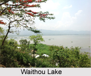
The Waithou Lake is in oval shape and is surrounded by natural beauty. Earlier the lake was once the biggest breeding ground for fishes which got hampered due to soil erosion and rapid urbanisation.
Attractions of Waithou Lake
The Waithou Lake is a beautiful picnic spot of Imphal. The lake is a blooming tourist destination that offers both entertainment and recreation. Boating, Angling, surrounding garden, food stalls etc. make is great fun to visit. The most attractive feature of the lake is the pineapple slopes gliding down into the lake. In the land around the lake, pineapples gardens are quite famous.
Pollution in Waithou Lake
Waithou Lake used to be a major breeding ground for different types of fishes like “Ngaton†till 1971-1972 .With the construction of Cheksabi barrage and ringbund during 1970s, the habitat of the fish has been completely vanished from the lake. Presently the Waithou lake ecosystem has been degrading badly and has turned into agricultural land due to the impact of soil erosion and urbanization in the surrounding hills. Moreover, eutrophication has become a very potent factor for the degradation of the lake. This encourage a lot of Ecological studies of the lake which indicate that altogether 35 macrophysics plant species are found distributed in different seasons of the year.
As such this is one of the picturesque lakes of Manipur which got seriously hampered due to the environmental disorder and urbanisation. This not only affected the ecological balance of the lake but also caused serious damage to the living organisms that used to breed in the shallow water of this lake.


