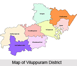
 Viluppuram district earlier formed a part of the district of Cuddalore in the Tamil Nadu state. It was afterwards bifurcated from the Cuddalore district and became a separate district on the 30th of September 1993. As a result of this, the history of the district of Viluppuram resembles very closely to that of the district of Cuddalore. Viluppuram district is one of the thirty districts of the state of Tamil Nadu, which is located in the southern parts of India. This district is known for the presence of a number of beautiful and famous temples, churches and a list of other natural attractions. The district had experienced the rule of the Cholas, the Pallavas, the Pandyas, Muslims and also the British.
History of Viluppuram District
The history of this district deals with a number of dynasties which ruled over it in the past and among them the Cholas were the early rulers. Karikala Chola was the most famous and powerful among the Chola rulers who ruled over Viluppuram. For a small time, the Cholas were overthrown by Simha Vishnu Pallava and the Region came under the Pallava rule. Vijayalaya Chola again revived the rule of the Cholas over this place and that was the beginning of great Chola dynasty. Later, the Chola rulers who came were weak and the power passed on to the hands of Eastern Chalukyas. The Cholas recovered their lost position but with the rise of Jatavarman Sundara Pandya I in A.D.1251, Chola rule ended. Pandyas ruled for more than fifty years, followed by Muslim domination from A.D. 1334 to A.D. 1378. By 1378, the region came under the rule of Vijayanagar Empire and Nayaks were appointed as the rulers of the region. In the year 1677, Shivaji took Ginjee area with the help of Golkonda forces. Then the Mughals came and in their regime, both the French and English acquired settlements in South Arcot. During the Anglo-French rivalry, the whole district was turned into a war land. After sometime, the whole area came under the control of British East India Company. It remained under British authority till the year 1947, when India became independent.
Geography of Viluppuram District
Viluppuram District is situated over an area of 7222.03 hectares. It was carved out from the South Arcot District on the 30th of September 1993 and was rechristened as the district of Viluppuram. The residual part of the erstwhile South Arcot district was named as Cuddalore District. The district is having its borders as the Cuddalore district to the East and South, Salem district and Dharmapuri district to the West and the district of Thiruvannamalai and Kanchipuram District to the North.
 The climate of this district is fairly dry and on the whole the climate is very healthy with a moderate temperature. The district receives moderate rainfall with the exception of Marakanam block and Vanur block, while in the Kandamangalam block and Koliyaur block the rainfall is moderate and it is very scarce in Kallakurichi and Sankarapuram.
The General geological formation of this district appears to be simple and the major portion of it is covered by the metamorphic rocks belonging to genesis family. There are three great groups of sedimentary rocks belonging to different geological periods. The Kalrayan Hills to the North represents an uninterrupted range of hills covered with some thorny forests and vegetation. Among the hills, the most beautiful part of the district lies, round about the Gingee Hills.
Administration of Viluppuram District
The administration of the Viluppuram district is having the Collector as the head. The district collector is assisted in his general work of administration by various revenue officers. Presently, the district of Viluppuram consists of one thousand four hundred and ninety revenue villages, four revenue divisions, eight administrative taluks, twenty two blocks, fifteen town panchayat unions, one thousand one hundred and four village panchayats and three municipalities.
Demography of Viluppuram District
Viluppuram district possesses a total population of 2960373 according to the 2001 census and it includes 1492442 males and 1467931 females. As per the 2001 census the urban population is 426917 and the rural population is 2533456. The density of population of this district in Tamil Nadu state is 410 per square kilometer and the people here are mainly agrarian.
Education in Viluppuram District
School education facilities are available in the district of Viluppuram. There are about one thousand seven hundred and seventy seven primary schools (including nursery schools), three hundred and eleven middle schools, one hundred and fifty high schools and about one hundred higher secondary schools. As far as higher education is concerned, arts colleges, engineering colleges, poly-techniques, industrial training institute and teacher training institutes are available to impart higher education in this district. There are Government-run hostels for boys as well as girls for schedule caste, schedule tribe, and other backward classes. According to the 2001 census the literacy rate of the district of Viluppuram is 73.47 percent.
Economy of Viluppuram District
The district of Viluppuram is developing in the industrial sector which also contributes significantly to the economy of the district. The Sugar industry is a major industry in the district with four sugar factories at Mundiyampakkam, Periasevalai, Kacharapalliyam and Mungailthuraipattu. The small scale industries include sixty seven rice mills, seventeen Sago factories, five rice bran oil extracting units and eight cotton ginning mills. The major food crops of the district of Viluppuram are paddy, ragi, cholam, cumbu, blackgram, redgram, varage and horsegram. The chief cash crops are sugarcane, groundnut, cotton, casuarina and coconut.
Tourism in Viluppuram District
Viluppuram District was formed after the bifurcated of the erstwhile South Arcot District from 30th September, 1993. This is the second largest district in the state of Tamil Nadu which is situated in the middle of Tiruchirapalli district to Chennai National Highways number forty five. The district is suitable connected by the rail, road and it also forms a major junction from where one can go to any corner of the Tamil Nadu as well as to other part of India. The Viluppuram district possesses a variety of tourist destinations which are more than one hundred years old. There are masques, temples and churches which are very old and famous.
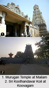
There are several tourist attractions which also includes a number of temples in Viluppuram district like Sri.Thiruvikirama Swamy temple at Tirukoilur, Sri.Vakirakaliamman temple at Tiruvakkaria near Tindivanam, Sri.Murugan temple at Mailam, Sri.Jain temple at Tirunaramkondnai near Ulundurpet, Sri.Singavaram Perumal temple at Gingee, Sri.Koothandavar Koil at Koovagam, Sri.Ranganathar temple at Singavaram, Sri.Meigandeswaran Koil at Tiruvennainallur, Dhabovanam at Thirukoilur, Thiruvakkarai Chandramolleswarar temple at Vanur, Angalaparameshwari temple at Melmalaiayanur, Lakshmi Narasimman Koil at Poovarasankuppam, Narasinga Perumal Koil at Parikkal, Marakanam Beach at Marakanam, Kalrayan Hills, Melnaariyappanoor Church, etc.


