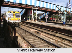
 Vikhroli is located in the suburbs of Mumbai. Vikhroli railway station is located on the Central Railway Line. The railway station was established in 1947 some time before the Indian independence. The main purpose was to serve the needs of the sprawling Godrej Complex in the vicinity. The railway line traverses the suburb, separating it into two essential parts (the `West` and the `East`), like many other areas in Mumbai. Kannamwar Nagar is located on the eastern side of the railway station. Vikhroli railway station caters to thousands of passengers every day because there are many educational institutions in the locality like, Brihan Mumbai Marathi Prathamic Shala, Kannamwar Nagar, Vikroli (E); Sandesh College of Arts, Commerce & Science (B.A., B.Com, B.Sc. & B.Sc (IT); St Joseph High School, Station Road, Vikhroli (W) (oldest school, built in 1957); Vidya Mandir High School, Vikhroli (E); Vikas High School, Vikhroli (E); Vikas Ratra College, Vikhroli (E); Utkarsha Bal Mandir, Vikhroli (E); Udhaychal high school, Vikhroli (E); Anjuman khairul Islam Urdu high school, Vikhroli(e); Don Bosco High School & Junior College of Arts, Commerce & Science, Vikhroli; Vikhroli Vidyalay Vikhroli; Guru Nanak English High School, Parksite Colony, Vikhroli (W); Tanzeem-e-Walidaen School (English Medium) Behind Church (by A.Wahid); Madhyamik Vidhyalaya, Kannamwar Nagar 1; Shree Siddhi Vinayagar English High School; Asmita College of Arts and Commerce for women; Shree Vikhroli Adarsh Vidyalaya Gujrati Medium, Vikhroli(E); Vikas collage of Arts, Science & Commerce.
Many people everyday use the railway station to reach their work place.


