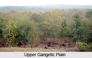
 The Upper Gangetic Plains moist deciduous forests in India lie on the alluvial plain of the Asia`s largest river, Ganges and also Yamuna, and cover a huge area of 263,100 square kilometers. The forests form a tropical moist broadleaf forest ecoregion in the northern India and cover most of the state of Uttar Pradesh and adjacent portions of Uttarakhand, Haryana, Madhya Pradesh and Bihar. The ecoregion is bounded by the Himalayan subtropical pine forests, Terai-Duar savannas and grasslands and Himalayan subtropical broadleaf forests of the Himalaya foothills on the north. It is bounded by the drier Northwestern thorn scrub forests and Kathiarbar-Gir dry deciduous forests to the west, on the south by the Narmada Valley dry deciduous forests of the Malwa and Bundelkhand uplands. It is also bounded by the more humid Lower Gangetic plains moist deciduous forests, on the east.
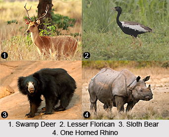
The climate of the Upper Gangetic Plains moist deciduous forests in India is tropical and rainfall is highly seasonal here. The annual rainfall in these forests averages less than 500 mm and they receive rainfall mainly during the months of June-September, caused by the southwest monsoon. The forests had Sal as the predominant tree in the ancient times; however, they are densely populated, at the moment. Several trees in the forests lose their leaves during the winter dry season. The forests used to harbour impressive populations of Tiger, Greater-One Horned Rhinoceros, Asian Elephants, Gaur, and Swamp Deer, many years ago. Apart from that, large hornbills also used to make daily migrations from their feeding areas to mature groves, where they nested in cavities of tall trees and roosted for the night. However, this natural biodiversity has been replaced by one of the densest human populations on Earth, at present. The substrate of the forests consists of deep alluvial soils deposited over the eons by the Ganges River.
 Apart from the Sal, the natural vegetation in the Upper Gangetic Plains moist deciduous forests in India also included the species like Terminalia tomentosa, Terminalia belerica, Lagerstroemia parviflora, Adina cordifolia, Dillenia pentagyna, Stereospermum suaveolens, and Ficus spp. etc. The forests have quite a rich fauna with seventy-nine mammal species. Though, none of the species is considered as endemic, there are some that are declared as threatened. These mammal species include the Tiger, Asian Elephant, Sloth Bear, Chousingha, etc. Possibly small refuge populations of Swamp Deer are also found in some habitat patches in these forests. The intact habitat landscapes and the protected areas within these forest fragments have already been included in a high-priority (Level I) TCU, which extends into the adjacent ecoregions to the north.
The rich bird fauna in the Upper Gangetic Plains moist deciduous forests in India has a total number of 290 species. None of the species are considered as eco-regional endemic species. However, the globally threatened species like Indian Bustard and Lesser Florican are also found in these forests. The other species like Indian Grey Hornbill and Oriental Pied-Hornbill also need mature habitat for nesting and they can be used as focal species for conservation management. The Ganges River flowing along side the forests also supports a population of Freshwater Dolphins, and the associated wetlands support a rich and diverse waterfowl community that includes many migrant bird species and also the Mugger Crocodile and Gangetic Gharial.


