 Unakoti district has been the name of a new district which was originally a portion of the North Tripura District, as a consequence of the bifurcation of this district which presently includes the northern parts of the state of Tripura.
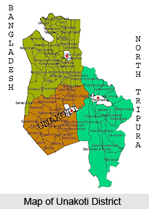
Geography of Unakoti District
The official bifurcation of Unakoti District came into existence from 21st January, 2012. The District headquarters of Unakoti district is Kailashahar. Unakoti district occupies a total geographical region measuring about 686.97 square kilometre. Bangladesh surrounds the Unakoti district on the western part, Dhalai District is present on the south-western portion and the North Tripura District surrounds the district on its eastern end.
Demography of Unakoti District
Unakoti district consists of a total population of approximately 2, 98, 574 and the literacy rate of this region measures about 88.29 percent according to the 2011 census. As per the records of this census, the female literacy rate of Unakoti District measures about 84.69 percent. Five Assembly Constituencies are existent in Unakoti District, namely Pecharthal, Chandipur, Pabiacherra, Kailashahar and Fatikroy. Karamcherra and Machmara are the two District Council Constituencies of Unakoti District.
Administration of Unakoti District
Kumarghat and Kailashahar are the two subdivisions of Unakoti District. Gournagar, Kumarghat and Pecharthal are the three developmental blocks located here. There exists 20 villages in the Sub Division of Kumarghat and 7 villages in the Sub Division of Kailashahar. There is one District Council office in the areas of Kumarghat and Kailashahar.
This article is a stub. You can enrich by adding more information to it. Send your Write Up to content@indianetzone.com


