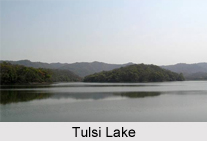
 Tulsi Lake is located in the Indian state of Maharashtra. More specifically, this lake is situated in the northern part of Mumbai and is one of the three lakes located in the Salsette Island, along with the Powai Lake and Vihar Lake. Both Tulsi Lake and Vihar Lake are located within the densely forested Sanjay Gandhi National Park which is famously also known as the Borivali National Park (BNP). This lake is considered to be the second largest lake in Mumbai, after Vihar Lake. Characteristically, this lake is a fresh water lake. This lake functions to supply a part of the city"s potable water. More specifically, the fresh water from this lake fulfills the water requirements of the southern part of Mumbai. The lake and its catchment are protected by the Brihanmumbai Municipal Corporation and Sanjay Gandhi National Park Authority.
History of Tulsi Lake
The plan to create the Tulsi Lake was envisaged in 1872 A.D and its construction came to an end in 1897 A.D. This lake was built by damming the River Tasso and its flow was redirected to the nearby Vihar Lake. It is known that the Tulsi Lake was established to act as a backup for the Vihar Lake.
Geography and Hydrography of Tulsi Lake
The catchment area of Tulsi Lake is about 6.76 square kilometres (2.61 square miles). The maximum height of hill in the catchment is about 400 m. The surface area of the lake is about 1.35 km sq. (135 hectares). On an average, the water of this lake is about 12 m deep. At full supply level (FSL), the gross storage capacity of this lake is about 2,294 million imperial gallons (10,430,000 m3). The amount of water supplied to Greater Mumbai is about 4 million imperial gallons (18,000 m3) per day. The highest overflow level recorded at the dam is about 139.17 m (456.6 ft). As far as the climate of the Tulsi Lake is concerned, the southwest monsoon sets in by mid June and lasts till September. During the rainy season the flood water flows into the Powai Lake and further down into the Mithi River. The period between July and August is normally expected to have maximum rainfall. The area occupied by the lake is reported to have a mean annual rainfall of about 2500 mm. The rain water from the catchment area of about 676 hectares of Powai-Kanheri hill ranges is the water source of this lake.
Thick and lush moist deciduous type vegetation draining into the lake occupies the hilly slopes and remains undisturbed. The flora and fauna of the Sanjay Gandhi National Park is relevant to Tulsi Lake, as this lake is located inside the park. More specifically, the fresh water crocodiles called Mugger or Marsh crocodiles are known to take shelter in the lake in sustainable numbers.
Tourism of Tulsi Lake
Tulsi Lake is considered to be a complete nature explorers` delight. Since the Tulsi Lake maintains a sustainable number of freshwater crocodiles of different sizes and it is difficult to sight them in the lake, the park authorities took a major step of establishing a crocodile park.
Visiting Information
Monsoon is generally considered to be the best season to visit Tulsi Lake. Tulsi Lake has transport availability for its visitors. Mumbai has air connectivity nationally and internationally. The nearest airport is Sahar International Airport which is situated at a distance of about 20 km from Tulsi Lake. The nearest suburban electric train station is Borivli East on the Western Railways, covering a distance of about 6 km from the station by road to the lake. This lake is located at a distance of about 38 km from Chhatrapati Shivaji Terminus (CST), a historic railway station in Mumbai. It is important to note that entry permits are required because the lake is located inside the Sanjay Gandhi National Park, where there is a presence of numerous crocodiles and other reptiles and many migratory birds in the lake. This entry permit is collected from the park authorities when one reaches the Tulsi Lake.
Related Articles:
Lakes of India
Lonar Lake
Powai Lake
Vihar Lake
Tulsi Lake


