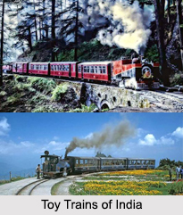
 Toy Trains of India which are small-sized engines were laid down during the British era for facilitating connectivity of the plains with all the hill resorts. These toy trains move on narrow-gauge tracts. Toy Trains of India play a significant role in the economy of the country as they are an important segment of the tourism industry. They intimate the passengers with the beholding picturesque locales. Following are some of the toy trains of India.
Kalka- Shimla Railway
Kalka- Shimla Railway of Himachal Pradesh covers the route from Kalka to Shimla. This toy train passes through nearly 107 tunnels and lofty arched bridges. From Kalka, the toy train encompasses a total distance of approximately 96 km in 6 hours. It was constructed in the year 1903 by the British, so that the officers could enter Shimla. It has the distinction of being a UNESCO (United Nations Educational, Scientific and Cultural Organization) World Heritage Site. The captivating view and stop over at the spectacular hill stations add thrill to the entire journey. Taksal, Dharampore, Gamma and Solan are some of the stations covered during the journey. The railway journey is considered to be one of the most scenic train journeys in India.
Kangra Valley Railway
 Kangra Valley Railway of Himachal Pradesh comprises of a toy train, which covers the route between Pathankot and Jogindernagar. The toy train has the distinction of being a UNESCO World Heritage Site. The journey on the toy train will provide the view of the rapid streams moving parallel to the track, several bridges, tea gardens of Palampur and the Dhauladhar Range.
Darjeeling Himalayan Railway
Darjeeling Himalayan Railway of West Bengal comprises of the Darjeeling toy train which journeys through the lower reaches of the Eastern Himalayas and reaches the rolling hills and tea plantations in Darjeeling. More specifically, it links the town of New Jalpaiguri with the spectacular hill resort of Darjeeling in West Bengal. Darjeeling toy train has the distinction of being the oldest of the historic toy train railways in India. The toy train line stretches up to 86 km, approximately. Since the line does not pass through tunnels, the passengers can get an uninterrupted view of the Himalayas.
Nilgiri Mountain Railway
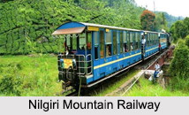
Nilgiri Mountain Railway of Tamil Nadu comprises of Nilgiri mountain toy train. It has the distinction of being the steepest railway in Asia. It is a narrow gauge train which covers the route from the town of Mettupalayam to the hill resort of Ootakamund (Ooty) at a speed of about 33 km an hour and covers a distance of about 46 km. The railway line is considered to be a historic railway line, which was completed in the year 1899. It serves as the railhead for the main line trains. Traveling at a speed of nearly 33 km per hour, this toy train runs through beautiful plains, green plantations, forested hillocks, thickly dense lush green forests, surrounding rivulets and hilly terrain. Cranking up almost 16 tunnels, the train crosses tall girder bridges on the way.
Matheran Hill Railway
Matheran Hill Railway of Maharashtra was a seven year old toy train, which connected Neral to Matheran, a tiny hill resort. This railway line served as the main route for reaching the resort lying close by to the city of Mumbai. The Matheran toy train became functional in the year 1907. Unfortunately, the derailment of coaches caused the toy train to be dysfunctional on the rail route.


