Introduction
 Chittoor is an important district located in the southern part of Andhra Pradesh and is a part of Rayalseema. The district has further been divided into 31 mandalas. The district of Chittoor is well known for the Tirupati Temple.
The granite industry is also of prime importance in the district of Chittoor. The Tirupati Temple in Chittoor is also a major source of earning for the district. This is because a large number of devotees throng the temple throughout the year.
Chittoor is an important district located in the southern part of Andhra Pradesh and is a part of Rayalseema. The district has further been divided into 31 mandalas. The district of Chittoor is well known for the Tirupati Temple.
The granite industry is also of prime importance in the district of Chittoor. The Tirupati Temple in Chittoor is also a major source of earning for the district. This is because a large number of devotees throng the temple throughout the year.
History of Chittoor<
The history of Chittoor district has been shaped by several Dravidian rulers. The early settlers of the district were the Kurumbas. After Kurumbas the Ballal dynasty had taken the reigns of the Chittoor district in hand. Then it was the Vijaynagara dynasty that rose to prominence and had started controlling the Chittoor district. It can be said that Chittoor was primarily occupied by the Dravidians and had witnessed the reigns of several dynasties. The Chittoor district was formed on 1st April 1911. The district was formed on the recommendation of the Pataskar Commission after dividing the districts of Cuddapah, Nellore and North Arcot.
Geography Of Chittoor District
 Chittor district of Andhra Pradesh lies in the extreme south of the state, approximately between 12`37` - 14`8` north latitudes and 78`3` - 79`55` east longitudes. It is surrounded on the east by Nellore district and Chengai-Anna district of Tamil Nadu, on the north by Anantapur and Cuddapah districts, on the West by the Kolar district of Karnataka State and on the South by North Arcot Ambedkar and Dharmapuri district of Tamil Nadu.
The entire district can be divided into two natural divisions:
1) One half is the mountainous plateau comprising 31 mandals of Madanapalle division
2) The Eastern half comprises the mandals of Puttur, Narayanavanam, Vadamalapeta, Kammapalle, Karvetinagar, Vedurukuppam, S.R.puram, Palasamudram, Nagari, Nindra, Vijayapuram, Pichatur, Nagalapuram, Satyavedu, Varadaiahpalem, B.N.Kandriga, K.V.B.Puram, Thottambedu, Srikalahasti and Yerpedu.
Eight mandals viz., Chittoor, G.D. Nellore, Puthalapattu, Penumuru, Gudipala, Yadamarri, Thavanampalle and Irala, stand almost as dividing line between the two natural divisions of the district.
In the Western region, the Eastern Ghats mountain range rise predominantly. They bend in a gradual slope towards the sacred Sheshchalam hills of Tirupati and pass through the erstwhile taluk of Chandragiri and finally enter the Nellore district. The general elevation of the mountains of the district is 2,500 ft above the sea level.
 The rivers that flow through the region are non-perennial in nature and remain dry for the major part of the year. The important rivers of the district are the Ponnai and the Swarnamukhi. The former is a tributary of the river Palar whereas the latter rises in the Eastern Ghats of the district and finally enters into the Nellore district. The other important rivers of the district are the Kusasthali, the Beema, the Bahuda, the Pincha, the Kalyani, the Araniyar and the Pedderu which flow in different mandals of the district. Besides the above rivers, there are a number of small hilly streams flowing in the district.
Chittoor district has a dry and healthy climate. The upland mandals are comparatively cooler than the eastern mandals except Chittoor where the climate is moderate. The annual rainfall of the district is 934 mms. The district has the benefit of receiving rainfall during both the south-west and north-east monsoon periods and the normal rainfall received during these periods is 438.0 mms and 396.0 mms respectively. The rainfall received from the south-west monsoons is more copious compared to north-east monsoons in the western mandals and in the central part of the district, whereas the rainfall received from north-east monsoons is comparatively copious in the eastern mandals of the district.
The major portion of the district is covered by red soils with portions of alluvial soil in Chittoor and Bangarupalem. The constitution of the soils in the district is: redloamy-57%; red sandy 34% and the remaining 9% is covered by black clay black loamy, black sandy and red clay.
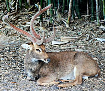
The climate, topography and geology have played an important role impressing the flora of the district. The district has hills and plateau and elevation ranges up to 1,318 metres. The floristic compositions in the forests vary from dry mixed deciduous to thorny scrub with occasional patches of dry, evergreen growth. The forests of this region can be broadly classified into the following three principal types-1) Dry tropical South Indian dry mixed deciduous forests; 2) Southern cutch thorn forest groups, and, 3) Tropical dry evergreen forests. Found in the forests of the district are a number of wild animals like sloth bear, wild dog, wild pig, porcupine, hyena, jungle cat, sambar, chital, black buck etc. A number of species of birds exist in this district such as grey babbler, vultures, partridges, peacock etc.
Demography of Chittoor
According to the census of 2001 the population of the Chittoor district is 3,745,875. The density of population in the district is 246 persons per square kilometer. Out of this population around 21.65 percent of the population is urban. The most commonly used language in the district is Telegu and other languages used are Tamil, English and Hindi language. The literacy rate in Chittoor is 66.77 percent. Among the literate population 77.62 percent of the male population is literate while 55.78 percent women are literate. The work force of the district comprises 46.85 percent of the entire population.
Temples of Chittoor District
 Temples of Chittor are located at Andhra Pradesh that encompasses some of the famous shrines and tourists spots of South India.
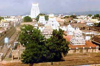
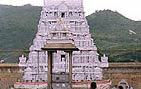
Sri Govindarajaswami Temple : It has an imposing gopuram, which can be seen, from a distance. Saint Ramanujacharya consecrated the temple in 1130 AD. The earliest records go back to the year 1235 AD. The Guruparampara accounts of the Vaishnavas ascribe the foundation of the shrine to Ramanuja. There are two shrines and not one, in the centre of the innermost enclosure. An outer wall encloses the two shrines. The shrine to the South is dedicated to Krishna, popularly known as Parthasarathi, while the shrine to the North belongs to Govindaraja. The earliest record found is on the innermost gopura and belongs to the fifteenth year of the Yadavaraya chief, Viranarasingadeva of 1224 AD.
Festivals: The festivals and functions are similar to those conducted in the Sri Venkateswara temple. The annual Brahmotsava at this temple is celebrated in the month of Vaisakha every year. The annual float festival is also celebrated every year. This Temple is the main attraction for pilgrims at Tirupati and the biggest in town.
 Agastheeswara Swamy Temple : This shrine lies at the confluence of three rivers Swarnamukhi, Bhima and Kalyani. Agasthya Mahamuni installed the Sivalinga and is called Agastheeswara linga. This temple faces the east and all parivaradevathas (family deities) are installed in niches. The Dwarpalakas at the entrance are beautifully sculptured and heighten the grandeur of the hall. It has three entrances and a grand compound wall. Inside the second prakaram, there is a separate shrine for Parvati and is called Vallimata.
There is a tank outside the compound. The nearby village was named Tondavada by the kings of Chandragiri, and was used as a rest house for visitors and keeping elephants. Opposite the Aalaya and in the middle of the river there is a mantap with statues of Balaji, Ayyappa, and Ganapati. There is also a small shrine for Rama, Sita, Lakshmana and Anjaneya near the tank.
Sivaalayam Temple : The ancient temple enshrines a big Sivalinga and lies on the western bank of river Bahuda. The recent renovation work has worked wonders for this temple. It has many Saivate gods installed in mandapams and small shrines.
Sivaalayam Temple : It is located in thick forest, infested with wild animals and inadequate transport facilities; this temple attracts lakhs of people, particularly on Mahashivratri festival every year. Shiva has been in this shrine for many centuries. It lies near Piler in the Chittoor district.
Pallikonda Sivaperuman Aalayam Temple : This shrine contains a rare icon of Lord Siva that in a reclining posture. It is a jewel in the crown of Saivism and so is the architecture. This black image is huge and is made with exquisite craftsmanship. Next to lies Parvati`s sannidhi that has a four-foot-high granite image and to its left, in a smaller shrine lies the Valmikeswara linga, and opposite it there is another Sivalinga.
 Tiruchanur Padmavati Temple : This temple is known as Alamelumangapuram. Goddess Padmavati is believed to be a very benevolent goddess who readily forgives her devotees if they are repent. Devotees are showered with plenty as soon as they receive her blessings while praying to her, in this temple. She is sitting in Padmasana holding two lotuses in her upper hands.
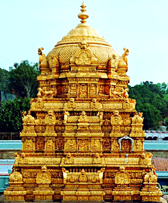
Tirupati Balaji Temple : The shrine is located on a hill at Tirumala, a group of seven hills known as Venkatachalam. This temple is located on the seventh peak of Venkatachala (Venkata Hill) and so the Lord is also called Venkatachalapati or Lord of the Seven Hills, which lies, on the southern banks of Sri Swami Pushkarini.
Kapilatirtham Temple : Tirupati, Chittoor is dedicated ton Goddess Laxmi. It is believed that one who takes bath in Kapilatirtham and starts the journey will not face any problems in reaching the temple. This was the ashram of Kapila maharshi and goddess Lakshmi resided in this Ashram when she came to earth.
Sri Kalahasti Temple
The Kalahasti temple is dedicated to Kalahasteswara worshiped as Vayu Lingam. The Vayu Lingam represents the element wind out of the five elements of Agni, Vaayu, Aakasam, Jalam and Prithvi. This is an important temple dedicated to Lord Shiva. This temple`s main idol is the vayu (air) linga.
Tourist places in Chittoor
Tourist places in Chittoor
 Chittoor is a district of the South Indian states Andhra Pradesh. This district is renowned for various ancient temples and beautiful architecture of them. Various other monuments of Chittoor have the Vijayanagara influence. Some of the watch worthy tourist places of Chittoor is given here:
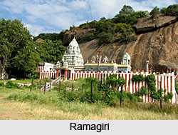
Ramagiri of Chittoor : Ramagiri is a beautiful place in the South Indian states Andhra Pradesh. It is situated about 5 km from Nagalapuram. This place has a long and interesting legend associated with it. It is nestled in picturesque mountains and sylvan scenery. There are two ancient temples here, one at the foot and the other on the top of a scenic hillock.
Ramagiri is also known as `Bhairava Kshethra`, which means the abode of Bhairava. `Lord Kalabhairava` is the presiding deity of the hill foot temple. It is one of the various forms of `Lord Siva` in which the Lord assumes the role of commander of the hill top temple. The above temple is dedicated to `Lord Muruga`, the son of the divine couple Lord Siva and goddess Parvathi.
There is a tank here near the temple and the water of it are said to have curative powers. This water comes from a perennial sweet water spring in the above mountain. This water flows into the tank from the mouth of the Holy Nandi Bull of Lord Siva.
 Kailasanadhakona in Chittoor : This is a picturesque part of the beautiful Nagiri hills of Chittoor. It is situated about 43 km from Tirupathi. There is a magnificent waterfall here, which flows along the huge mountains and its water takes the goodness of minerals and enrichments the mighty mountains. This water is believed to have curative properties. Now, this place is being regarded as a good picnic spot.
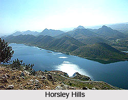
Horsley Hills in Chittoor : The Horsley hill is situated in the Chittoor district of Andhra Pradesh state. It is the shelter for the heat affected devotees of Tirupathi in the hot season. This wonderful hill resort was discovered by W.D. Horsley in 1870. It is located along the grand ranges of Eastern Ghat and is about 150 km from Tirupathi by road via Madanapalle.
Madanapalle in Chittoor : The pleasant climate of this place all round the year makes it worth visiting. Since the time of Dr. Annie Besant, this place has been an educational and cultural centre.
Gurramkonda in Chittoor : This is one more hill station of the Chittoor district. It is situated about 17 km from the Horsley Hills and 32 km from Madanapalle on way to Cuddapah. The English meaning of the term `Gurram` is horse and `Konda` means Hill. Therefore, `Gurram Konda` means Horse Hill in Telugu nomenclature. There is a magnificent fort atop the hill from where fascinating views of the low-lying area can be enjoyed. Tipu Sultan had the headquarters of the Governor in the `Rangini Mahal` here.
 Sompalle in Chittoor : This place is famous for some ancient temples. It is situated about 37 km from Horsley hills and 50 km from Madanapalle. All the temples are built following the Vijayanagara architecture. The excellent rock carvings of a nearby temple attract lots of tourists here. There is a 46-meter high monolithic pillar in front of the temple. Another attraction here is the `Kalyanamandapam`, which is carved out of stone.
Arogyavanam in Chittoor : This place is renowned for the Union Mission T.B. Sanatorium, which provides yeoman service to the suffering people here. The T.B. patients take shelter here and get treated with a minimum amount. A `Post-Graduate Diploma` course in T.B. is also conducted here.
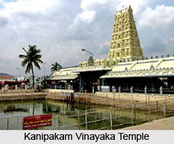
Kanipakkam in Chittoor : This place is well known for a number of ancient temples. It is situated about 10 km north of Chittoor. The elegant Chola architecture is quite evident in the temple structures. A temple of Lord Vinayaka can be seen here. This temple celebrates a grand Hindu festival for seven days before and after `Vinayakachathurthi Festival`.


