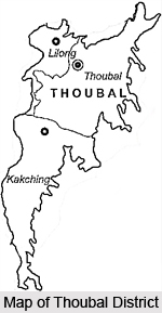
 Thoubal District occupies the bigger portion of the eastern half of Manipur Valley. This administrative district of Manipur has its headquarters at Thoubal town. Thoubal District lies between 23 degree 45 minutes north and 24 degree 45 minutes north latitude and 93 degree 45 minutes east and 94 degree 15 minutes east longitude. It is bounded in the north by Imphal District, in the east by Ukhrul and Chandel districts, in the south by Chandel and Churachandpur districts and in the west by the districts of Imphal and Bishnupur. Thoubal District has an area of 514 sq kms. Its average elevation is about 790 metres on an average above the sea level.
History of Thoubal District
The ancient history of Thoubal District is quite unclear. However, history of Thoubal District states that in the recent past the district has seen many bloody and disgraceful battles. It is in this district, at Khongjom, that the last battle of the independence of Manipur was fought in April, 1891 against the British Empire. Thoubal District came into existence in May, 1983 under the notification of state government of Manipur and under the Manipur Land Revenue and Land Reforms Act 1960. Under this notification, Thoubal sub-division of the erstwhile Manipur Central District (now Imphal district) with all its administrative units was transferred to form a new district with the name of Thoubal with its head-quarters at Thoubal. Later, in November, 1983, Thoubal was bifurcated into Thoubal and Kakching sub-divisions comprising of Kakching and Waikhong Tehsils.
Geography of Thoubal District
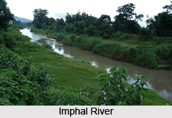
Although the district is a part of the valley, the area of the district is not entirely plain. Geography of Thoubal District is also composed of several rivers that are flowing through the district. It also includes many lakes. Imphal and Thoubal are the main rivers of Thoubal District. Topography of Thoubal District also comprises several hills. The district has an equitable climate with evenly distributed rainfall. The district is not rich in mineral resources. Red clay is found in some places of the district.
Administration of Thoubal District
Administration of Thoubal District has two community development blocks one within each sub-division. It has nine main towns namely, Lilong (Thoubal), Thoubal, Yairipok, Shikhong Sekmai, Wangjing, Heirok, Kakching, Kakching Khunou and Sugnu and a part of Samurou whose major portion is in Imphal District. Thoubal and Kakching are municipal blocks.
Culture of Thoubal District
 Thoubal District is mainly inhabited by the Meiteis. The important fairs and festivals observed in the district reflect a mixed culture and age old traditions and local beliefs. The biggest festival of Thoubal District is Dola Jatra. It is observed in the month of March beginning with full moon day of Phalguna. It is a festival of colours and all people participate in it. Ratha Yatra is another important festival celebrated in the district and it is performed in the month of Jyestha for seven days. On the first and the seventh day raths carrying idols of Jaganath, Balabadra and Subhadra are drawn and flowers and bhogs are offered to them. Other significant festivals of the district are Janmashtami, Durga Puja, Ningol Chakouba and Manipuri New Year day. On Ningol Chakouba all women, married and unmarried, are invited and fed by their relatives and gifts are presented to them after the feast. Id Ul Fitr, Id Ul Zuha, and Muharram are also celebrated in the district. Among the tribal mention may be made of the Gang-Ngai festival of the Kabui Tribe and the Kut festival of the Kukis are major tribal festival of Thoubal District.
Economy of Thoubal District
Agriculture is the main occupation of the people of Thoubal District. Economy of this district is hugely dependent on agriculture and other agriculture related activities. Animal husbandry and fishing are other areas contributing to the economy of Thoubal District. Soil of this district is highly fertile offering great scopes of cultivation. With the advancement of modern technologies, double and triple cropping is practiced in the district.
Tourism in Thoubal District
Tourism in Thoubal District means visits to a number of historical and beautiful sites. Some of the popular places of interest are as follows -
Khongjom: It is situated above 10 kms to the south of Thoubal, the district headquarters. It is the place where last war of Manipur`s independence against the British soldiers. It has got a memorial erected on a small hillock.
Sugnu: Situated 74 kms from Imphal, the place is an important trading centre on the south of the district. This place offers a beautiful view of Imphal River.

Waithou: The place is important for its scenic beauty. The place is known for its pineapples.
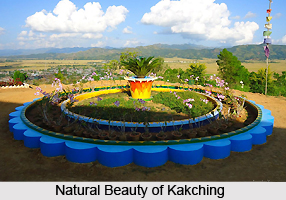
Kakching: It is the sub-divisional headquarters of Kakching sub-division and is a famous trading centre of a variety of vegetables, fishes and rice next to Thoubal, the biggest town in the district.
Pallel: It is a place situated at the border of Thoubal and Chandel districts and is the meeting place of plain areas of Thoubal and the hill areas of Chandel. With its hills and rivers the place has a beautiful landscape.
Thoubal District does not have any power house. It gets its supply of power from the Loktak Hydro Electric Power House. Thoubal District has a fairly developed system of road transport. All towns and important villages in the district are connected either by the National or State or district or village roads.


