Home > Indian History > Geography of India > Mizo Hills
Mizo Hills
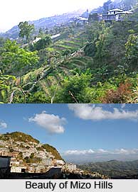
Mizo hills, also known as the Lushai hills are in Mizoram and partly in Tripura, India. These hills are amazingly enveloped with dense bamboo jungle and experience pleasantly temperate climate throughout the year.

Share this Article:

Mizo Hills, MizoramThe Mizo hills are located in Mizoram and partly in Tripura state of India. The Mizo hills are also known as the Lushai hills. They are a part of the Patkai range. The Mizo hills rise more than 2000 m (6560 ft) near the Myanmar border. Mizo hills are a treat to the eyes; they are amazingly enveloped with dense bamboo jungle and open grass covered slopes. The cherry on the top is the Tropic of Cancer runs through the heart of Mizoram, and hence, it has a pleasantly temperate climate throughout the year. These hills draw a good number of photographers, explorers and travel enthusiasts.

Inhabitants of Mizo Hills
The inhabitants of these hills are Lushais and other Mizo tribes however the population is extremely sparse. Since the early times, the Kukis were regarded as the original inhabitants of Mizo Hills. The Lushais were not heard of until the year 1840, when they invaded the district from the north.

Flora and Fauna of Mizo Hills
The Mizo hills have an outstanding view with its colourful flora and vegetation, making it an admirable place to look out for. They have widely-spread dense bamboo jungle, though at certain parts in the east smaller rainfall has given rise to open grass-covered slopes with groves of oak, pine and rhododendrons. Also in the intermontane valleys, shifting agriculture and some terrace cultivation are practiced by the people.

The Mizo hills are also home to an impressive range of fauna. The Dampa Tiger Reserve is the largest wildlife sanctuary in this hilly area. The fauna includes swamp deer, leopard, tiger, elephant and hoolock gibbon.

Attractions of Mizo Hills
The hills offer wonderful opportunities for exploration and photography. They are surrounded by amazing landscapes, rivers and waterfalls. `The Blue Mountain` is the highest peak in Lushai hills. It rises to a height of 2165 metres. Important rivers that flow through this hilly state are Tlawang, Sonai, Kolodine, Tuivawl and Kamaphuli. The Vantawang waterfalls are located close to the Thenzawl hill station. One can best explore the hills by trekking; it is an amazing way to have a glimpse of the natural wilderness here.


Share this Article:

Related Articles

More Articles in Geography of India


Geography of Uttar Pradesh
The fourth largest State in India UP is located in the Northern part of India whose area is 2,36,286 sq Kms.
Geography of Maharashtra
Covering an area of 308,000 sq. km, Maharashtra, the third largest state in India.
Geography of Kerala
Geography of Kerala includes plains, hills, valleys and coasts. With the Arabian Sea in the west, the Western Ghats in the east and networked by several rivers, Kerala enjoys diverse geographical features.
Geography of West Bengal
The geography of West Bengal is unique with high peaks of the Himalayan range in the north, the Bay of Bengal in the south and the remaining region is covered with both plains and plateaus.
Geography of Jharkhand
Geography of Jharkhand is comprised of the rich mineral resources and the highly agricultural prospect in this state.
Geography of Sikkim
Geography of Sikkim is characterised by a vast array of magnificent hillock that extends from one corner of the state to the other.
Geography of Meghalaya
The suitable climate, highland plateaus, rivers and the flora and fauna together forms the geography of Meghalaya.
Geography of Mizoram
Mizoram is surrounded by hills, valleys, rivers, waterfalls and lakes. The hills range from 1000 meters to 2000 meters. Rivers, lakes and waterfalls also play major role in forming the land of Mizoram.
Geography of Jammu & Kashmir
Jammu and Kashmir is encompassed by valleys. Some of the dominant valleys of the state are Kashmir Valley, Tawi Valley, Chenab Valley, Poonch Valley, Sind Valley and Lidder Valley etc. Jhelum River is the only major Himalayan River which flows through the Kashmir valley. Indus, Tawi, Ravi and Chenab Rivers are the major ones flowing through the region.
Geography of Daman and Diu
Daman and Diu is situated on the west coast of India and are the smallest union territories of India.
Geography of Goa
Geography of Goa occupies a prime location along the Konkan coastal belt on the western coast of India. The state is bordered by Maharashtra in the north and Karnataka in the south. The Western Ghats in the east contribute to the flora and fauna of Goa.
Geography of Arunachal Pradesh
Geography of Arunachal Pradesh reveals that it is a hilly tract nestled in the foot of Himalayas.
Geography of Kutch
Geography of Kutch District is covering an area of 45,612 km. Kutch District is the largest district in the state of Gujarat.
Geography of Ladakh
Geography of Ladakh mainly comprises the huge Karakoram Range with long stretch of cold desert which mark the region separately from the rest of the states of Indian subcontinent. Surrounded with the mountain ranges from all corners this small region separates Indian subcontinent from rest of the Asian continent.
Geography of Rajasthan
Geography of Rajasthan defines the dry topography with arid climate of the western mountain region.
Geography of Tamil Nadu
The Indian state of Tamil Nadu is located in the Northern hemisphere in the hot zone.