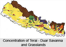
 The Terai-Duar savanna and grasslands in India form an ecoregion that stretches across the middle of the Terai belt, from the state of Uttarakhand through southern Nepal to the northern part of West Bengal. These savanna and wetlands are actually a mosaic of tall grasslands, savannas and evergreen and deciduous forests. The grasslands are counted amongst the tallest in the world, and are well maintained by silt deposited by the yearly monsoon floods. Some of the notable grasses found in these wetlands include the Kans Grass and Baruwa Grass. The ecoregion is also home to several endangered species like the Indian Rhinoceros, Elephants, Tigers, Bears, Leopards and also some other wild animals.
Located at the base of the Himalayas, the Terai-Duar savanna and grasslands ecoregion is about 25 kilometers wide. The ecoregion is a continuation of the Gangetic Plain and it also stretches from southern Nepal`s Terai, Bhabar, and Dun Valleys eastward to Banke. The ecoregion covers the Dang and Deokhuri Valleys along the Rapti River and a small portion of it reaches into Bhutan. Each ends of the ecoregion crosses the border into India`s states of Uttar Pradesh and Bihar.
 The Terai-Duar savanna and grasslands in India contain the highest densities of Tigers, Rhinos, and Ungulates in Asia. The ecoregion has already been included in the Global 200 and one of the features that elevate it to this list, is the diversity of ungulate species. The extremely high levels of ungulate biomass recorded in riverine grasslands and grassland-forest mosaics, is also another unique feature of this ecoregion. The very tall grasslands of this ecoregion are rare worldwide in comparison with short grasslands and they are also considered as the most threatened. These tall grasslands indicate that the region has mesic or wet conditions and nutrient-rich soils.
The Terai-Duar savanna and grasslands in India cover a wide range of habitat types like the savanna grasslands, evergreen and deciduous forests, thorn forest, and steppe. The forests in this ecoregion are low in elevation and are hot and humid in the summer. The temperatures in these forests reach 40o degree C, during the late dry season. The annual monsoon floods deposit silt from the rivers that meander across the grasslands. The areas buried in silt, usually return to tall grasslands by the end of the following monsoon, and the low-lying areas inundated for a few days only, are recharged with an annual load of nutrients. The Nepal Terai include the tallest grasslands in the world and some of the characteristic species in this region include Saccharum spontaneum, Saccharum benghalesis, Phragmitis kharka, Arundo donax, Narenga porphyracoma, Themeda villosa, Themeda arundinacea, and Erianthus ravennae, etc. The ecoregion also includes the shorter species like Imperata cylindrica, Andropogon spp., and Aristida ascensionis, etc. Most of the grasses are fire and flood resistant and can spread rapidly under favourable conditions.
 The Kans Grasslands among the Terai-Duar savanna and grasslands in India are dominated by the tall grass species that is the first to colonise the exposed silt plains after the retreat of monsoon floods. This is the keystone habitat for Rhinoceroses and other large mammal species. On the other hand, the Baruwa Grasslands dominate the next terrace above the S. spontaneum band along the river`s edge. Some of the other important species found in the ecoregion include the Imperata cylindrica, Chrysopogon aciculatus, Eragrostis spp.; Cymbopogon spp., Arundo donax and Phragmites karka, etc. The Sal forests are quite common along the alluvial terrain blends into the forested hills. These forests average between 25 and 40 meters in height but can reach up to 45 meters under favourable conditions. Some of the common associates of the Sal tree in these forests include Terminalia tomentosa, Syzygium cuminii, Anogeissus latifolia, Terminalia alata, T. belerica, T. chebula, Lagerstromia parviflora, Dillenia pentagyna, Syzigium operculata, Carya arborea, and Buchanania latifolia, and also Chir Pine on higher reaches.
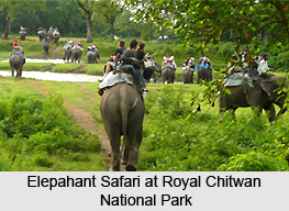
The ecoregion formed by the Terai-Duar savanna and grasslands in India also contains small patches of tropical deciduous riverine forest that are mainly dominated by species like Mallotus philippinensis, Syzigium cuminii, Bombax ceiba, Trewia nudiflora, and Garuga pinnata, etc. There is another variant, tropical evergreen forest found in this ecoregion and this is made up of the species like Michelia champaca, Syzigium, Cedrela toona, Garuga pinnata, and Duabanga, etc. Though, much of the ecoregion has been converted to farmland, the Royal Chitwan National Park and Royal Bardia National Park situated in this ecoregion preserve significant sections of habitat. The Royal Chitwan National Park in southern Nepal contains more than 500 of the world`s 1,000 endangered greater one-horned Rhinoceroses and about seventy breeding Tigers. These two National Parks are also home to some of the greatest concentrations of Rhinoceros and Tiger remaining in South Asia.
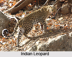
There are also several other National Parks that are situated within the premises of the ecoregion formed by the Terai-Duar savanna and grasslands in India. The parks include the Royal Chitwan National Park the Royal Bardia National Park, the Royal Shukla Phanta Wildlife Reserve, and the Dudwa National Park. These parks together contain approximately eighty-five species of breeding Tigers. The ecoregion also overlaps with three Level I TCUs and one Level II TCU. Out of these, the Chitwan-Parsa-Valmiki is a Level 1 TCU that spans southern Nepal and northern India. This TCU was evaluated as the most important among all the alluvial grassland units containing tigers on the Indian subcontinent. The TCU supports a healthy Leopard population and it is also home to at least a small population of the rare Clouded Leopard, the last new large mammal to be reported for Chitwan.
 Many of the Terai-Duar savanna and grasslands in India support five important deer species like the Swamp Deer, Sambar, Axis Deer, Hog Deer, and Barking Deer. They also support an unusually diverse assemblage of Cervids. Apart from that, four large herbivores like the Asian Elephant, Greater One-Horned Rhinoceros, Gaur, and Nilgai or Blue Bull can also be found in this ecoregion. The ecoregion is home to several endangered mammalian herbivores as well and these include the Asiatic Wild Buffalo and the near-endemic Hispid Hare. Another highly endangered ungulate found in the ecoregion is the Pygmy Hog.
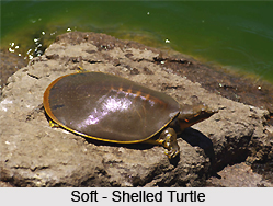
The riverine grasslands among the Terai-Duar savanna and grasslands in India provide critical habitat for now-endangered Reptiles like the rare, primitive Crocodilian, the Gharial, Mugger Crocodile, and Soft-Shelled Turtles. Small portions of two endemic bird areas are overlapping with this ecoregion. Three near-endemic bird species can be found in this ecoregion including the Manipur Bush-Quail, Grey-Crowned Prinia and the Spiny Babbler. Among these, the Manipur Bush-Quail is considered as vulnerable species. The Terai`s diverse grasslands, riparian woodlands, hill forests, and scrub forests are home to more than 375 bird species, out of which, 130 are threatened birds. Some of the most important grassland-associated birds include the Bengal Florican, Lesser Florican, Sarus Crane, and the Large Grass Warbler, etc.


