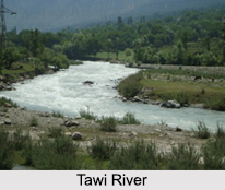
 Tawi River is a river flowing through the city of Jammu in the Indian state of Jammu and Kashmir. Tawi River is considered sacred and holy. Tawi River, also called as "Surya Putri" in ancient text is a major left bank tributary of Chenab River. Tawi River is the main river, which flows through Jammu city and has its name attached to the inception of the city. The people of the Jammu city have great cultural and religious attachments with the Holy River Tawi. Water of the Tawi River is the main source of drinking water particularly for the Jammu region.
Origin of Tawi River
Tawi River originates from the lap of Kali Kundi glacier and adjoining area southwest of Bhadarwah in the Doda district of Jammu and Kashmir. The catchment area of the river stretches up to an area of 2,168 square kilometres, extending to the Indian border at Jammu and falls in the districts of Jammu, Udhampur and a small part of Doda.
Confluence of Tawi River with Chenab River
Tawi River stretches to a length of about 141 kilometres (88 miles). The river flows through steep hills on either side, excepting the lower reach, for about 35 kilometres (22 miles). The river is about 300 metres (980 feet) wide at the bridge in the Jammu city. After traversing through the city, the river crosses into the Pakistan-administered Punjab and confluences with the Chenab River.
Flow of Tawi River through Jammu
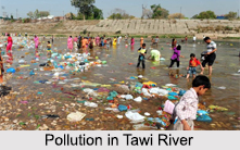
Tawi River traverses through and divides the city of Jammu in two segments. The old Jammu town is located on the hill overlooking the river Tawi. The new town is across the river. Tawi River is a major source of drinking water for the old city. Untreated sewage in the new city pollutes the river as it passes through it.
Bridges on Tawi River
Four bridges have been built over the Tawi River in Jammu city - two join Gumat with Vikram Chowk, the third connects Gujjar Nagar with the Bahu Fort area while the other joins Bhagwati Nagar with Ratnuchak. A fifth bridge has been built over the river on the city bypass near Nagrota.
Mythological Beliefs associated with Tawi River
The Hindus in the city of Jammu believe that the Tawi River was brought to Jammu by Raja Pehar Devta, to cure his father. He was given the throne of the city and declared as the "Raja" with the blessings of "Bawe Wali Shri Mata Kali Ji". Most Hindus of the city at present perform the "Mundan" ceremony of their children at the "Deva Sthan" of "Pehar Devta Ji" also referred with love as "Bawa Pehar" having his abodes at various places in the Jammu region, but the primary abode at nearby village Katal Batal near Nagrota. The main temple has images of "Pehar Devta" along with snakes and Goddess Kali. People offer food there to fishes in the form of wheat balls and pray for their well-being and prosperity.
 Distinction of Tawi River from Manawar Tawi River
Tawi River is not to be confused with the Manawar Tawi River which is a small rivulet originating in the Thana Mandi area in the Rajouri district in Jammu. Manawar Tawi River is named after a Pakistani commando Major Malik Munawar Khan Awan who operated in the area during operation Gibraltar 1965. The Manawar Tawi flows through Chingus, Nowshera and enters Pakistan-administered Punjab at Manawar, to join the Chenab River.
Pollution in Tawi River
Tawi River is getting highly polluted and its pollution level has reached at an alarming position. The Tawi River is now being used as a big sewage and its level has very much reduced. Besides polluting the river, the waste material is raising the level of river bed exposing localities along the banks to floods. The Industrial discharge, chemicals, polythene bags affect the water of Tawi River. This has made the river water unfit for consumption that was used for drinking since centuries.


