Home > Indian History > Geography of India > Tarsar Marsar Lake
Tarsar Marsar Lake
Tarsar and Marsar Lakes are referred to as the ‘Twin Sisters’ of Aru Valley. Together, these lakes form a wonderful rocky trekking trail and provide great opportunities to explore the richness of Jammu and Kashmir tourism.

Share this Article:

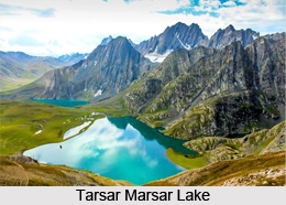
Tarsar Marsar Lake, Lakes of IndiaTarsar Lake is an almond-shaped, oligotrophic alpine lake situated in the Kashmir Valley, specifically in Aru, Anantnag district, Jammu and Kashmir, India. The lake is separated by a mountain forming another lake of the same nature known as "Marsar Lake", which is in the vicinity of Dachigam National Park. Together these two lakes are referred to as the "Twin Sisters".

Marsar Lake is a beautiful alpine water body full of scenic natural beauty. The lake is located at a distance of about 5 km from Nagberan village. Marsar Lake along with Tarsar Lake forms a challenging trekking trail that adds another feature to the adventure of Jammu and Kashmir tourism.

Geography of Tarsar Marsar Lake
Tarsar Lake is dominated by the peaks of the Kolahoi mountain massif some 20 km to the east. Nestled at an elevation of 3795 meters, the lake is eye-catching and measures 2 km in length and around 0.8 km in width. The lake is separated by a mountain with a minimum peak elevation of 4,000 metres (13,000 ft) from another lake known as "Marsar Lake.

The Tarsar Lake is drained by an outlet stream which falls into the Lidder River at Lidderwat, 15 km to the east. The Marsar Lake on the other hand drains out and flows in the opposite direction of the Tarsar Lake.

Flora and Fauna of Tarsar Marsar Lake
During the winter, the Tarsar Lake freezes and is covered by heavy snow. It has floating ice even in the summer. The basin of the lake is surrounded by a sheet of alpine flowers. The Geum, Blue Poppy, Potentilla and Gentian are relatively common. Hedysarum flowers are found in late spring throughout the area around the lake.

During summer there are breeding colonies of migratory birds, including Bar-Headed Goose, Lammergeyers, High-Flying Choughs, Himalayan Golden Eagles, Cinnamon Sparrows and Black Bulbuls. The basin of Tarsar and the adjoining Dachigam National Park constitute one of the most important habitats of the Kashmir Stag, Ibex, Musk Deer, Snow Leopard and Himalayan Brown Bear, and in the higher reaches, the Golden Marmot.

How to Reach Tarsar Marsar Lake
Tarsar Lake is one of the beautiful tourist places to visit in Pahalgam. Tarsar Marsar Lake is accessible only during the summer. In winter, the treks are closed because of the heavy snowfall. It can be reached from Srinagar, via a 102 km motorable road which leads through Anantnag and Pahalgam to the Aru trekking camp. Due to the steepness of the trek, it is preferable to approach the lake by the Aru-Lidderwat trek and return via the Sumbal-Sindh Valley trek. Another accessible route to Tarsar and Marsar is a place called Nagberan via Tral.


Share this Article:

Related Articles

More Articles in Geography of India


Geography of Uttar Pradesh
The fourth largest State in India UP is located in the Northern part of India whose area is 2,36,286 sq Kms.
Geography of Maharashtra
Covering an area of 308,000 sq. km, Maharashtra, the third largest state in India.
Geography of Kerala
Geography of Kerala includes plains, hills, valleys and coasts. With the Arabian Sea in the west, the Western Ghats in the east and networked by several rivers, Kerala enjoys diverse geographical features.
Geography of West Bengal
The geography of West Bengal is unique with high peaks of the Himalayan range in the north, the Bay of Bengal in the south and the remaining region is covered with both plains and plateaus.
Geography of Jharkhand
Geography of Jharkhand is comprised of the rich mineral resources and the highly agricultural prospect in this state.
Geography of Sikkim
Geography of Sikkim is characterised by a vast array of magnificent hillock that extends from one corner of the state to the other.
Geography of Meghalaya
The suitable climate, highland plateaus, rivers and the flora and fauna together forms the geography of Meghalaya.
Geography of Mizoram
Mizoram is surrounded by hills, valleys, rivers, waterfalls and lakes. The hills range from 1000 meters to 2000 meters. Rivers, lakes and waterfalls also play major role in forming the land of Mizoram.
Geography of Jammu & Kashmir
Jammu and Kashmir is encompassed by valleys. Some of the dominant valleys of the state are Kashmir Valley, Tawi Valley, Chenab Valley, Poonch Valley, Sind Valley and Lidder Valley etc. Jhelum River is the only major Himalayan River which flows through the Kashmir valley. Indus, Tawi, Ravi and Chenab Rivers are the major ones flowing through the region.
Geography of Daman and Diu
Daman and Diu is situated on the west coast of India and are the smallest union territories of India.
Geography of Goa
Geography of Goa occupies a prime location along the Konkan coastal belt on the western coast of India. The state is bordered by Maharashtra in the north and Karnataka in the south. The Western Ghats in the east contribute to the flora and fauna of Goa.
Geography of Arunachal Pradesh
Geography of Arunachal Pradesh reveals that it is a hilly tract nestled in the foot of Himalayas.
Geography of Kutch
Geography of Kutch District is covering an area of 45,612 km. Kutch District is the largest district in the state of Gujarat.
Geography of Ladakh
Geography of Ladakh mainly comprises the huge Karakoram Range with long stretch of cold desert which mark the region separately from the rest of the states of Indian subcontinent. Surrounded with the mountain ranges from all corners this small region separates Indian subcontinent from rest of the Asian continent.
Geography of Rajasthan
Geography of Rajasthan defines the dry topography with arid climate of the western mountain region.
Geography of Tamil Nadu
The Indian state of Tamil Nadu is located in the Northern hemisphere in the hot zone.