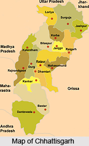
 Surguja District is located in the northern part of Chhattisgarh. Uttar Pradesh, Jharkhand, Orissa and Madhya Pradesh are adjoining to Surguja District. This district of Chhattisgarh has over extension between south-eastern parts of Vindhyachal-Baghelkhand region of peninsular India. It is located between 23 degree 37 minutes 25 seconds to 24 degree 6 minutes 17 seconds north latitude and 81 degree 34 minutes 40 seconds to 84 degree 4 minutes 40 seconds east longitude. Surguja District has a total area of about 16359 sq km; it is 244.62 km long east to west and 167.37 broad North to South. Ambikapur is the district headquarters.
History of Surguja District
The presence of various temples stone carvings and archaic remains show the evidence of existence of this region before Christ (BC). In 4th BC before the arrival of Maurya Empire, this region was in the Lord of Nanda clan. Before 3rd BC this region was divided into tiny parts. Further, it was undertaken by Rajput kings belonging to Rakshal clan in Palamau, Bihar. In 1820 Amar Singh took control over Surguja state who had been crowned as "Maharaja" in 1826. In 1882 Raghunath Sharan Singh Deo had taken his control over Surguja state. According to some holy books, Lord Rama had visited Surguja during his 14 years of exile period.
 There are many places associated with Ramayana. Many places are named after Lord Rama, Laxmana and Sita; these are Ramgarh, Sita-Bhengra and Laxmangarh.
Geography of Surguja District
Geography of Surguja District is spread over high lands, plateaus, hills and plain lands. A huge portion of its total area is covered by forests. The major rivers flowing through the district are Kanhar, Moran, Rihand River and Mahan. The climate of the district basically includes hot summer and even distributed rainfall in the monsoon season. The region falls in the Tropical Thermal belt. Soils of Surguja District are classified in four major classes and these are Red and Yellow Soils, Alluvial Soil, Laterite Soil and Black Soil.
Culture of Surguja District
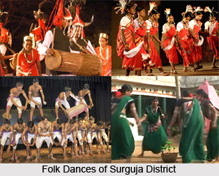
Culture of Surguja District is mainly tribal in nature as tribal population constitutes the major portion of the total population. Among these primitive tribes are Pando and Korwa, who are still living in forest areas. Several festivals, music and dance forms make the culture of Surguja District a unique one. Saila Dance, Suwa Dance, Karma Dance are some of the popular traditional dances of the district. These dances are performed on festivals and other occasions.
Tourism in Surguja District
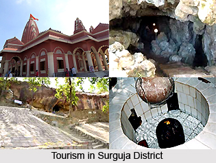 There is no dearth of attractive tourism options in Surguja District. People from different parts of the country come and explore the various places of interest offered by the district. Deepadih, Deogarh, Ramgarh Hill, Kailash Caves, Shivpur Shiv Temple, Budha Temple, Mainpat, Nageshwar Shiv Temple, Tata Pani and Kudargarhi Devi are some of the major attractions of Surguja District. The tribal culture and the natural scenic beauty of Surguja District enhance the charm of tourism in this tribal district. Semarsot Wildlife Sanctuary and Tamor Pingla Wildlife Sanctuary are the two popular wildlife sanctuaries of Surguja District.
Most of the people of Surguja District are engaged in agriculture and farming. About 90 per cent of the working population is dependent on agriculture.


