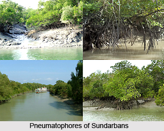
 The Sundarbans freshwater swamp forests, is considered to be one of the most endangered and endemic ecoregions in India, as it is nearly extinct, at present. The main reason behind this has been hundreds of years of habitation and exploitation by one of the world`s densest human populations. The forests are located in the vast, productive delta of the Ganges and Brahmaputra rivers, and they are exceptionally productive due to the annual alluvial deposits made by the rivers. The brackish swamp forests lie behind the Sundarbans Mangroves where the salinity is more pronounced. The forests also lie between the upland Lower Gangetic plains moist deciduous forests and the brackish-water Sundarbans mangroves that border the Bay of Bengal.
The water is slightly brackish in the Sundarbans freshwater swamp forests in India and becomes quite fresh during the rainy season. The freshwater plumes from the Ganges and Brahmaputra rivers during rainy season and push the intruding salt water out and also bring a deposit of silt. These forests also straddle the boundary between the Indian state of West Bengal and Bangladesh, just like the vast mangrove ecoregion. The southwest monsoon brings heavy rain to the forests during the months of June to September and the forests also witness widespread destruction, due to frequent, devastating cyclones sweeping in from the Bay of Bengal. The annual rainfall in the forests can exceed 3,500 millimeters (mm) and the daytime temperatures can rise above 48 degrees Celsius (oC) during the monsoon months. Coupled with the humidity, the temperatures can be unbearable.
 The habitat in the Sundarbans freshwater swamp forests in India is so fragmented that it is quite difficult to ascertain the composition of the original vegetation of this ecoregion. However, the vegetation in the freshwater swamp forests are principally characterised by the plant species like Heritiera minor, Xylocarpus molluccensis, Bruguiera conjugata, Sonneratia apetala, Avicennia officinalis, and Sonneratia caseolaris, with Pandanus tectorius, Hibiscus tiliaceus, and Nipa fruticans along the fringing banks. The forests also provide an important refuge for the Tiger, together with the mangrove ecoregion.
Apart from the Tigers, the Sundarbans freshwater swamp forests in India are also home to a large number of fifty-five known mammal fauna species. None of the species is considered to be endemic to the ecoregion. However, there are several threatened mammal species available in these forests that include the Capped Langur, Smooth-Coated Otter, Oriental Small-Clawed Otter, and Great Indian Civet, etc. The forests also provide habitat to the Leopard and several smaller predators like the Jungle Cat, Fishing Cat, and Leopard Cat. The Sundarbans freshwater swamp forests are home to a rich variety of bird species. The total number of bird species found in these forests is 190 and none of them are considered as endemic. However, some of the species should be called as focal species for their role as predators in this ecosystem that includes a significant aquatic component. These species include the Osprey and Grey-Headed Fish-Eagle. The most notable fish species found in the Sundarbans freshwater swamp forests include the Gangetic Dolphin and the three crocodile species like the Marsh Crocodile or Mugger, Estuarine Crocodile, and Gharial.


