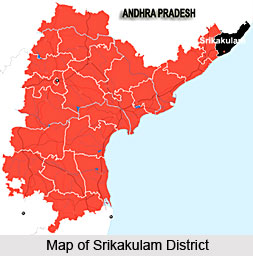
 Srikakulam district is located towards the extreme north of Andhra Pradesh. The headquarter of the district is Srikakulam. The early name of the district was Chicacole. The district of Srikakulam was formed in the year 1950 after separating it from the Vishakapatnam District. Followed by the year 1950, the district had undergone several major territorial changes in the years 1969 and 1979.
Geography of Srikakulam District
Latitudinal expanse of the district is between 18.20 degrees and 19.10 degrees north. Longitudinally the district stretches between 83.50 and 84.50 degrees east longitudes. The total land area of the district is measured as 5837 square kilometers. The district is bounded by Vizianagaram District in the south and west, the state of Orissa lies to the north of Srikakulam while Bay of Bengal is the eastern boundary of the district.
The major rivers that flow across the district are Nagavali, Mahendratanaya, Bahuda, Vamsadhara, Champavathi and Kumbikotagedda.
The climate of Srikakulam district is more or less characterized as humid. Lot of rainfall is brought in the region by the south-west and north-east monsoon winds. The average annual rainfall in the district in the region is quite high. The flora of Srikakulam comprises mostly moist deciduous and dry evergreen forests. The forest of the district includes sal trees, Savannah vegetation and a lot more variety of trees.
On the other hand the fauna of the region is not widely varied. Most of the animals which were found in the region in the early days have more or less become extinct in the present days because of the destruction caused by human expansion. Still some of the common animals and birds existing in the area are leopard, hyena, wild goat, chital and birds like Peacock, pigeon, myna, patridges and goose are also found in the area.
Demography of Srikakulam District
According to the census of 2001 the population of Srikakulam is 2537593. The density of population in the district is 435 persons per square kilometer. Number of females in the district is more than the number of males. Most people in the district of Srikakulam are rural based. The literacy rate in the district is 55.64 percent. Again in terms of literacy more number of males is literate as compared to the number of females.
Education of Srikakulam District
 Education in the district of Srikakulam is managed by both government as well as private institutes. Although the district is small in size yet it has several graduate and post graduate institutes. It also has a number of engineering and medical colleges. Apart from these general institutes there are also some law, nursing and B.ED institutes in the district. Hence it can be said that the education system in the district is well improved.
Economy of Srikakulam District
The main economic resources of the district are timber, bamboo, manganese, mica and graphite. As far as industry is concerned jute constitutes the most important industry in the region. Even tourism accounts for a major economic share.
Tourism of Srikakulam District
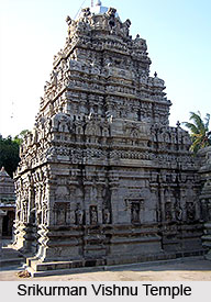
The district of Srikakulam is known as the land of temples. Temples in the district of Srikakulam are known for its architectural splendour. The temples of the region which needs special mention are Sun temple of Arasavally, Srikurman Vishnu Temple and Srimukhalingam temple. The other tourist destinations in the district are Baruva and Kaviti which are worth mentioning because of their scenic beauty.


