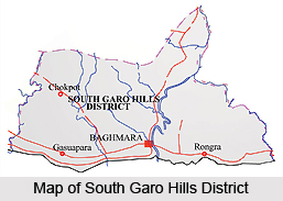
 South Garo Hills District lies in the southern part of Meghalaya, and was created on 18th of June, 1992. This district of Meghalaya has its administrative headquarters at Baghmara, the only town in the district. Total population of South Garo Hills District as per Census 2001 is 1,00,980, out of which male population is around 51,000 and female population is nearly 48,100. Further, literacy rate according to 2001 Census is 55.82 percent, male literacy rate accounts for almost 62.60 percent and female literacy rate is around 48.61 percent.
Location of South Garo Hills District
South Garo Hills District is situated between 25 degree 10 minutes and 25 degree 35 minutes north latitudes and 90 degree 15 minutes and 91 degree east longitude. This administrative district covers a total area of 1887 sq kms. It is bounded in the north by East Garo Hills District, in the east by West Khasi Hills District, in the west by West Garo Hills District and in the south by Bangladesh.
History of South Garo Hills District
As per the history of South Garo Hills District, the early inhabitants of the district were Garo tribe. Eventually, the region came under the control of British rulers from the authority of Mughal Emperors. Further, Garo Hills was annexed by the British in the year 1873. In 1979, Garo Hills District was divided into two separate districts namely East Garo Hills District and West Garo Hills District. In 1992, former West Garo Hills District was further bifurcated into two administrative districts namely West Garo Hills District and South Garo Hills District.
Geography of South Garo Hills District
Geography of South Garo Hills District is hilly with difficult terrains. The tropical vegetation covers areas up to an elevation of around 1000 metres.
 The majority of the forests fall in this zone. It embraces evergreen, semi-evergreen and deciduous forests, bamboo thickets and grasslands including riparian forests and swamps. These forests mainly consist of Shorea robusta and in certain area Tectona grandis has also been introduced. The ground flora in deciduous forests is very poor and seasonal, while in evergreen forests, species of Alpinia, Amomum, Colocasia, Costus, Hedychium, etc. are not uncommon. Different varieties of beautiful birds are found in abundance in the forest areas of the district.
Administration of South Garo Hills District
Administration of South Garo Hills District comprises four Community and Rural Development Blocks and these are Baghmara Development Block, Rongara Development Block, Chokpot Development Block and Gasuapara Development Block. Moreover, there are three Assembly Constituencies within South Garo Hills District. Administrative set-up of South Garo Hills District is headed by the Deputy Commissioner. He is assisted by other officers.
Culture of South Garo Hills District
Culture of South Garo Hills District is highly influenced by the traditions and lifestyle of Garo Tribes. They are the main inhabitants of this region. Their songs, dances, festivals, ceremonies, folklores, religious beliefs, etc. constitute the culture of South Garo Hills District. It is basically of tribal nature. Their society is matrilineal and all their festivals are mainly associated with harvest and cultivation. Culture of South Garo Hills District is unique and diverse.
Tourism in South Garo Hills District
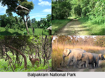
Tourism in South Garo Hills District offers a pleasurable experience to the travellers coming from different parts of the country. There is no dearth of sightseeing options in this district. It includes several places of religious as well as historical importance. Some of the major attractions offered by South Garo Hills District are Balpakram National Park, Siju Cave, Siju Bird Sanctuary, Rongsaljong Agal and Rongsobok Rongkol.
Baghmara, the district headquarters of South Garo Hills District can be easily reached from Guwahati.


