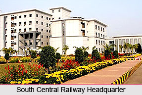
 South Central Railway is Indian Railway`s one of the 16 zones with its headquarters at Secunderabad. Inaugurated in the year 1966 on 2nd October, South Central Railway has become one of the most important transport routes in south central India. South Central Railway has its important divisions at Hubli and Vijayawada, which belonged to the Southern railways and was later clubbed with the Solapur division and the Secunderabad division of the Central railway to create a new railway zone, the South Central Railway. However it is from New Guntur, Hyderabad, Vijayawada, Nanded, and Guntakal that the main railway operations of the South Central Railways are performed. Vijayawada is a main centre of South Central Railway. Vijayawada station is considered as the busiest station of the South Central Railway routes as it is the main linking point between northern and southern India. It is the connecting point for all the trains running from north India to south India. In the recent times of course the Indian Railways have assigned few more trains to this zone.
Lately, South Central Railway has introduced computerized passenger reservation system facility in 85 stations, Passenger Operated Enquiry Terminals (POET), Inter-active Voice Response System (IVRS) for rail reservation and enquiry and National Train Enquiry System (NTES) for information on train movement. Close Circuit Television (CCTV) is available in all the important stations of South Central Railway for proper safety survey. Besides, several important mail or express trains, South Central Railway is also popular for its Rajdhani and Shatabdi trains.
South Central Railway tracks run from Goa (eastern side) to Vizag (western side) and Khandwa (northern side) finally to Tirupathi (southern side). Running through the prime tourist centers in the states of Andhra Pradesh, Karnataka, Goa, Maharashtra and Madhya Pradesh, South Central Railway links several popular tourist spots of the country. The South Central Railway of India has been serving the Indian passengers since 40 years. Over all these years South Central Railway has grown into a modern transportation network, which has succeeded in fulfilling the passengers aspirations and demands. Since the formation of South Central Railway, it was included as the 9th zone of Indian Railways. The South Central Railway serves the states of Andhra Pradesh, Madhya Pradesh, Tamil Nadu and some regions of Maharashtra. South Central Railway, also abbreviated as SCR, has come a long way since its steam engine and wooden seats days and has facilitated its passengers with state of the art configuration, diesel and electric engines, telescopic passenger coaches and digital communication system.


