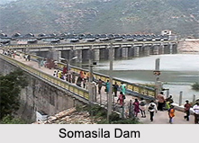
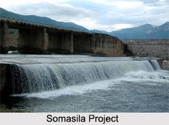
 Inaugurated in the year 1989, it falls under the Ananthasagaram Mandal of the Somasila village. The foundation stone of this project was laid on 4th June, in the year 1975 by the then Hon"ble Chief Minister of Andhra Pradesh Sri Jalagam Vengalrao garu. Standing on the Pennar River, the Somasila Dam is a great tourist spot. The Krishna water scheme to the Chennai Telugu Ganga Canal is build adjacent to this Dam.
Structure of the dam
Somasila Dam falls into the category of Earth-filled and Gravity dam. The earth-filled dam is also called an earthen dam or terrain dam, and is made of compacted earth. It is the opposite of a rock-filled dam. The Somasila is also called a gravity dam because it has been designed to hold back water primarily by using the weight of the concrete material alone. The height and length of the dam are 39m (128ft) and 760m (2493 ft) respectively.
Somasila Reservoir and Water Sources
The Somasila Reservoir impounded by the dam has a total capacity of 2.20862 Cubic Kilometres. With a total surface area of about 212 square kilometers, the reservoir also gets water due to gravity, from the Srisailam reservoir, in the Krishna Basin. The Srisailam Dam is constructed across the Krishna River in Kurnool district of Andhra Pradesh. It is currently India"s second largest capacity working hydroelectric station. Somalia Reservoir mainly gets fed or irrigated by the Srisailam Right Main Canal or the SRMC. The reservoir is a part of the Indian Rivers Inter-link project. Under this project, the structural plan of the dam has been done in such a manner, that it is connected with the Nagarjunasagar reservoir in order to increase the inflow of water.
 Irrigation Schemes of Somasila Dam
The total area served by the irrigation project is 4,05,500 acres wet (stabilization) and 1, 79,000 acres (New I.D) ayacut. It is also envisaged to transmit 30 thousand million cubic feet (TMC) of water to Kandaleru Reservoir under the Telugu Ganga Project for irrigation in Nellore and Chittoor districts. The project even supplies water from River Krishna to the city of Chennai for drinking purposes. In addition to this, 2.40 TMC of water is also allocated to the towns of Nellore, Kavali, Gudur and Tirupathi under this project. Along with this, the irrigation scheme covers a number of Mandals near the Somasila village, Nellore, Sangam, Thotapalli Gudur, Vidavalur, Nellore Rural, Kaligiri, Kavali, Kaluvoy, Chejerla, Ananthasagaram, Atmakur and A.S.Peta being some of them.
Kandaleru Reservoir
Kandaleru Reservoir receives most of its water from the Somasila Dam. It is mainly fed by a link canal from the dam. Thus it is an important irrigation scheme under the Somasila Reservoir. The Kandaleru Dam itself is also an important irrigation project. It is built on the Kandaleru River in Rapur Mandal of the Nellore district, in the Indian state of Andhra Pradesh. The Kandaleru Dam project is also a part of the Telugu Ganga Project.
The project surrounding the Somasila Dam- The Somasila Project, carries prime importance because it supplies the very basic necessity i.e water not only to the adjoining areas like Nellore, Kavali, Atmakur, etc., but also to distant areas for example Chennai. It also provides drinking water facilities to the upland drought prone areas in Udayagiri and Atmakur constituencies. It plays an important role in power generation, upto a capacity of 12 MW. It also prevents floods in the Pennar river by transferring the flood waters to other areas in the form of drinking water.


