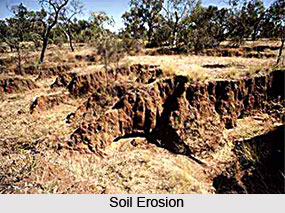
Soil Erosion in Western zone is the outcome of the physiological factors particular to the place. A large chunk of Western Zone is arid or semi-arid. Extreme form of soil degradation due to aridity is wind erosion. Wind erosion is common in most arid and semi-arid regions. The weighted average annual rain fall in the Western zone is 610 mm. Over 8 months are physiologically dry. The areas affected fall in Rajasthan, Gujarat and Haryana. Wind erosion affects the coastal region of Gujarat too. In these regions, rainfall is scanty and erratic and very little or almost no surface vegetation exists. Biotic activities like grazing and soil working loosen the soil particles. High velocity wind shifts them.
 In Jammu & Kashmir and Himachal Pradesh, moisture conditions are better. Skeletal soils of cold region, podsolic soils, mountain meadow soils and hill loam soils occur. Though thorn and dry deciduous forests predominate in the Western Zone, hills support a variety of forest ecosystems. They range from tropical and sub tropical broad leaved forests (below 1200 metres) to coniferous forests (above 3000 metres). Area is prone to several erosion hazards. Landslides occur mainly due to weak geological formations. Deforestation causes rill and gully erosion. Even these, too, degenerate into landslides, if not treated promptly. Faulty land use practices lead to soil losses. Construction of roads in hills disturbs drainage patterns very seriously. This often leads to concentrated flows and to deepening of drainage lines down the slope. Land slides result due to faulty disposal of water through road side drains more widely than is normally believed. Such disposals triggered the majority of notorious landslides dotting hill roads in Himalayas.
The southern part of this zone is semi-arid. Red soils predominate. Black soils, too, occur. This region receives 80-90 percent of its annual rainfall within only 30 to 70 hours. Bursts of rains are interspersed by long dry periods. Forests are tropical deciduous and thorny. Sheet erosion is extensive. Gully erosion follows sheet erosion. This is especially so on overgrazed forest lands. Soil depths are poor and the forest soils have low fertility. Moisture stress is the most limiting factor.
Soil Erosion in Western Zone is thus mostly caused by wind due to the dry conditions prevailing in the major portion of the land area here.


