 Siwan District is situated in the western part of Bihar. It was originally a sub-division of Saran District, which in ancient days formed a part of Kosala Kingdom. Present Siwan District came into existence in the year 1972. Siwan town is the district headquarters. The geographical location of Siwan District is confined between 25 degree 53 minutes to 26 degree 23 minutes north latitudes and 84 degree 1 minute to 84 degree 47 minutes east longitude.
Deoria District of Uttar Pradesh bound it in the west, Gopalganj District in its north, Saran District in the east and Ghaghara River in the south, beyond which lies the district of Ballia (Uttar Pradesh).
History of Siwan District
Siwan District derived its name from `Shiva Man`, a Bandh Raja whose heirs ruled this area till Babar`s arrival. Maharajganj, which is another sub-division of Siwan District, may have found its name from the seat of the Maharaja there. A recently excavated marvelous statue of Lord Vishnu at Village Bherbania indicates that there were large numbers of followers of Lord Vishnu in the area. According to some legends, Siwan is also known as Aliganj Sawan after the name of Ali Bux, one of the ancestors of the feudal lords of the area. Siwan was a part of Banaras Kingdom before the invasion of Muslim rulers. Later on, Sikandar Lodi included this area in his kingdom. After the battle of Buxar in 1765 it became a part of Bengal. Siwan played an important role in 1857 independence movement.
Geography of Siwan District
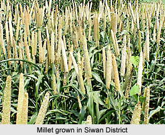
Siwan District is mainly a plain and fertile agricultural land. It has highest temperature in May and lowest temperature in January. The highest rainfall period is August and September. In summer, it often faces cyclones. The land of Siwan cannot be divided into botanical zones. Crops are cultivated in the district as per the seasons. There are mainly two major crops that is Kharif (Its period is June to September and the main crops are Maize, Paddy, Sugarcane, and Millet etc.) and Rabi (Its period is October to March and the, Main crops are Wheat, Grams, Peas, Mustard, Soya beans, Sunflower etc.). The main fruits grown in the district are Mango, Guava, Banana, and Papaya. Vegetables are also grown according to the season. Siwan District has no forest area.
Demography of Siwan District
According to the Census 2011, the Siwan District had a population of 3,318,176. Out of which the male and female were 1,672,121 and 1,646,055 respectively. The Siwan population of District constituted 3.20 percent of total population of Bihar. The average literacy rate of Siwan in 2011 was 71.59 compared to 51.65 of 2001. If things are looked out at gender wise, male and female literacy were 82.77 and 60.35 respectively. The total literates in Siwan District were 1,994,056 of which male and female were 1,155,972 and 838,084 respectively.
Tourism in Siwan District
Siwan District has several popular tourist attractions. This district offers some sites of historical and religious importance. The travellers can visit Amarpur; a village situated 3 kms west of Darauli. In this village, ruins of mosque of red bricks on the bank of Ghaghara River are still available. This mosque was constructed during the reign of Shah Jahan, Mughal Emperor (1626-1658) under the supervision of the Naib Amar Singh but the work was left incomplete. Faridpur situated just near Andar is the birthplace of Maulana Mazharul Haque who played an important role during the freedom movement. Darauli is the block headquarters. Initially its name was Daras Ali, which later on was changed into Darauli. There is reminiscence of Mughal period ruins where a big mela is held every year on the Kartik Purnima. These places of interest are worth visiting.
Transport facilities in the district are not inadequate. Railways and roads are the two main modes of reaching the district. The North Eastern Railways crosses through Siwan district for 45 kms.


