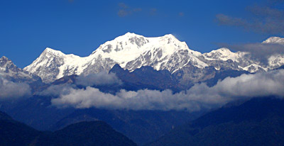
 Sikkim Himalaya is described as one of the more physically accessible sections of the Himalaya. Sikkim is a state that is lying in the north-eastern part of the country. The travelers can reach this physically accessible part of the Himalaya just within four days from Kolkata. Sikkim constitutes part of the Eastern Himalayas. This region is known for the heavy rain that it receives as compared with the Western Himalayas. It was in the year 1883 the first serious climbing began in Sikkim. The climber was W. W. Graham who, with two Swiss guides climbed jubonu (5936 m). After the year 1883, the first serious attempt on Kabru (7338 m) was made in the year 1907 by Rubenson and Aas, two Norwegians. The state of Sikkim is totally surrounded by Nepal to the west, China to the north, Bhutan to the east and Indian state of West Bengal to the south. The state of Sikkim is given huge importance because of its strategic location. This state has always remained as a favorite among the trekkers, mountaineers and explorers across the globe. In the past, this particular region of Himalaya was known as Basyul, which means the hidden land.
One of the earliest traverses of the Passanram and Tal-ung valleys was made by Dr E. Allwein and H. Pircher, members of the second unsuccessful German expedition to Kangchenjunga in 1931. Lhonak in the days before the Second World War was fast becoming a popular climbing area. One of the more interesting climbs in the mid-thirties was C. R. Cooke`s first ascent of Kabru in November 1935. Sikkim continued to be the favorite area for treks and short mountaineering holidays during the war years and later. It was in the early fifties, Sikkim began to receive its first set of geographical restrictions, particularly for foreigners. Gradually with the worsening of the Indo-Chinese relationship permission even to Indian nationals became considerably controlled in certain areas, mostly around the border passes into Tibet. Because of all these reasons, the expeditions required greater preparation and it usually took longer to obtain permits beyond the Inner Line and hence, mountaineering activity became extremely limited. It was in the year 1975 that the members of the Indian Air Force and the Indian Mountaineering Foundation attempted Talung from the Guicha la and Talung glacier.
In the year 1976 Harish Kapadia and Zerksis Boga were the first civilians (in fifteen years) to get permission. They repeated some of the popular routes: to Green Lake, over the Thieu la into Lohnak, over the Lugnak la to Thangu, over the Sebu la to Mome Samdong and back to Chungthang. Since then, most of the expeditions have been around the east Rathong glacier, the valley that is used by the students of the Himalayan Mountaineering Institute located at Darjeeling. Rathong has been climbed by Indian pre-Everest expeditions and Army teams in the years 1964 and 1987. Peaks to the north are still considered as `Armed Forces Territory`. Thus, Gurudongmar (6715 m) was climbed from the northeast by an Assam Rifles party led by Norbu Sherpa in the year 1980. Rathong was again a target for a Gurkha Rifles team in the year 1987. Moreover, Kokthang (6147 m) that lies across the pass south of Rathong has been claimed by several expeditions.
Thus, it can be said that Sikkim Himalayan region offers tremendous mountaineering expedition opportunities.


