 Shillong is a hill station in the northeastern part of India and it is the capital of Meghalaya. It is one of the smallest states in India. This hill station is situated at an average altitude of 4,908 feet above sea level, and its highest point is Shillong Peak at 6,449 feet. This place takes its name from that of a tribal deity `Shulong` who is believed to reside on the Shillong Peak. The tribes of Khyrim, Mylliem, Maharam, Mallaisohmat, Bhowal and Langrim trace their descent from Shillong. Shillong is also a proud possessor of one of the best 18 hole golf courses in the world. This place was known to the British as "Scotland of the East".
History of Shillong
Shillong was made the civil station of the Khasi and Jaintia Hills in 1864 by the British. In 1874, on the formation of Assam as the Chief Commissioner`s Province, it was chosen as the headquarters of the new administration because of its convenient location between the Brahmaputra and Surma valleys and because of its climate which was much cooler than tropical India. Shillong remained the capital of undivided Assam until the creation of the new state of Meghalaya on 21st January 1972. When Shillong became the capital of Meghalaya then Assam moved its capital to Dispur in Guwahati.
 Geography of Shillong
Shillong is located at 25.57 ° N and 91.88 ° E. It lies on the Shillong Plateau, which is the only major uplifted structure in the northern Indian shield. The city lies in the centre of the plateau and it is surrounded by hills, three of which are revered in Khasi tradition- Lum Sohpetbneng, Lum Diengiei and Lum Shillong.
Climate of Shillong
Generally the weather of Shillong is pleasant. In the summer, the temperature varies from 23 ° C to 29 ° C and in the winter the temperature varies from 4 ° C to 10 ° C. According to the Köppen`s climate classification, the city features a subtropical highland climate (Cwb). Its summers are cool and very rainy, while its winters are cool and dry. Shillong is considered to be the vagaries of the monsoon. Monsoons in this region arrive in June and it stays almost till the end of August.
Demographics of Shillong
According to 2011 India census, Shillong had a population of 143,229 of which 49% are males and 51% females. 12% of the population was under 6 years of age. The average literacy rate was 93%; the male literacy rate became 95% and female literacy rate was 91%.
Tourism in Shillong
Shillong is replete with several natural attractions due to its strategic location amidst Garo and Khashi hills. Some of them are:
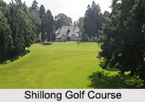
Shillong Golf Course: Shillong has one of the largest golf courses (the worlds" wettest) in Asia. It is considered to be one of the few natural golf courses in Asia. A group of British civil service officers introduced golf to Shillong in 1898 by constructing a nine-hole course. The present 18-hole course was inaugurated in 1924. The course is set in a valley at an altitude of 5200 ft covered with pine and rhododendron trees. Shillong Golf Course is considered to be the "Glen Eagle of the East" at the United States Golf Association Museum.
Motphran: The "Monument of France" which is locally known as "Motphran" was erected in memory of the 26th Khasi Labour Corps who served under the British in France during World War I. It bears the words of the famous Latin poet Horace- "Dulce et decorum est pro patria mori". These words can be roughly translated as "it is sweet and honorable to die for one`s countryâ€. Currently this monument is standing in a dilapidated condition.
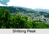
Shillong Peak: It is a picnic spot, which is located 10 km from the city. Situated at an altitude of 1966 meters above sea level, Shillong Peak offers a panoramic view of the scenic countryside and it is the highest point in the state.
Capt. Williamson Sangma State Museum: This government museum offers insights to the lifestyle of the tribal people including their culture and tradition. This museum is in the State Central Library complex where monuments for the great patriots of the state were erected besides the statue of Smt. Indira Gandhi and Netaji Subhash Chandra Bose.
Don Bosco Centre for Indigenous Cultures: The Don Bosco Museum is part of DBCIC (Don Bosco Centre for Indigenous Cultures). DBCIC comprises research on cultures, publications, training, and animation programs. The museum is a place of knowledge sharing on the cultures of the northeast in particular and of culture in general. DBCIC with its Don Bosco Museum is situated at Mawlai, Shillong.
Entomological Museum (Butterfly Museum): This is a privately owned museum only devoted to moths and butterflies. It is located 2 km away from Police Bazar in Shillong.
 Wards Lake: This lake is locally known as Nan-Polok. It is an artificial lake with garden and boating facilities.
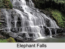
Elephant Falls: Elephant Falls is 12 km away from the city. The mountain stream descends through three successive falls, which are set in dells of fern-covered rocks.
Mawsynram: 56 km from Shillong, Mawsynram is famous for the giant stalagmite formations, which has been shaped like a Shiva Linga. It is locally called Mawjymbuin.
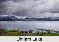 Umiam Lake: The lake is 17 km from Shillong and offers water sports facilities including sailing, water scooter, and water skiing.
Other Visiting Places in Shillong
Apart from the above mentioned places, there are some other places in Shillong and near to it, which are worth visiting and tourists often flock to those places to visit. The places are Chrysalis the Gallery, State Museum, Bishop and Beadon Falls, Spread Eagle Falls, Sweet Falls, Crinoline Falls, Margaret Falls, Lady Hydari Park etc.
Visiting Information to Shillong
The best times to visit this place are October to November and March to April. Nearest airport to this place is Shillong Airport or Umroi Airport, which is 35 km from Shillong. To reach the place by train, Guwahati railway station would be the nearest rail station. Shillong is also well-connected by road to other neighbouring states and cities. It can be reached by road by accessing NH40.
