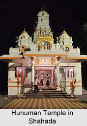
 Shahada is one of the six Tehsils in the Nandurbar district of Maharashtra.
Location of Shahada
Shahada is a town situated in the northwest corner of Khandesh Region of Maharashtra. Shahada town was in Dhule District until 1st July 1998, when Dhule district was divided to create Nandurbar District. Shahada is especially known for educational facilities and religious village Dakshin Kashi which is 15 km from Shahada.
History of Shahada
Near Shahada lies a village called Prakasha village, which is around 15 km south-west of Shahada, is the second most important excavation site in Maharashtra. In the year 1955, B K Thapar on behalf of Archaeological Survey of India excavated site near confluence of Tapti River and Gomai River. Excavation exposed 17 meter deep occupational deposit - hammer stones, restricted use of copper, low grade bronze dating back to 1700 BC. Around 6 km north of Shahada there are several centuries old sculptures complex in Gomai River. The main sculpture is popularly known as Mahavira sculpture and the entire sculptures complex is popularly known as Pandavleni or `Panch Pandava`. This evidence suggests that Shahada and area on the banks of Gomai River has been inhabited at least since 1700 BC. Shahada-Kukdel municipality was established in the British period, in the year 1869. As per 1961 the census population of Shahada was 13338. Shahada name came to be known as local Gurjari meaning Saadha Bhada means simple.
Geography of Shahada
Shahada is on average 455 feet above sea level. As the Satpura Mountain Range just 30 km north of Shahada, the bedrock is on an average 5 metres below the ground level. Due to natural or human-made underground caves, the ground at Savalde village, 5 km away from Shahada, caved in during heavy rain during August 2006 and caused an earthquake of magnitude 2.8 on Richter Scale on 10th November 2006. As seismograph stations are installed away from traffic to avoid false-positive results from ground vibrations, Shahada`s seismograph station of the Sardar Sarovar Project is installed in the same village. The soil above the bedrock is good for farming except in some areas. Average rainfall is 552 mm.
Climate of Shahada
The climate is hot for most of the year. The maximum temperature reaches up to 48 degree Celsius in summer and minimum temperature fall up to 9 degree Celsius in the winter. The climate of Shahada is on the whole dry except during the south-west monsoon season and winter months December to February. The year may be divided into four seasons. The cold season continues from December to February. Hot and dry season from March to June. The south-west monsoon season starts from the last week of June and lasts up to the end of September. The post-monsoon season October and November remains hot and dry.
Demography of Shahada
According the Population Census in the year 2011, Shahada had a population of 49,697, being 52% male and 48% female. Shahada has an average literacy rate of 71%, higher than the national average of 59.5%: male literacy is 77%, and female literacy is 65%. In Shahada, 14% of the population is under 6 years of age.
Culture of Shahada
The languages and dialects spoken in Shahada town and Nandurbar district are Marathi language, Ahirani language, Gujar language, Hindi language and Braj language.
Economy of Shahada
The agriculture is the main occupation of the people. Sugarcane, bananas, cotton, maize, jowar, wheat, food plant etc. are the main crops harvested all year round. Villagers from nearby towns come to Shahada for shopping or health treatment. Hence Shahada town remains busy with many shopping markets. The major shopping markets are Purushottam Market No.1, Purushottam market No.2, 64 Gaala Market, Kashinathbhai Market, Pushpkamal Market, Shibaam market. Shahada town has branches of Government-owned banks - State Bank of India, Central Bank of India, Dena Bank, Bank of India, Union Bank of India. The reputed private bank, ICICI Bank, HDFC Bank has also its branch in Shahada town. Apart from these banks, there are few local banks. Mahaveer Patpedi, Dhule District Central Co-Operative (DDCC) Bank Ltd is notable among local banks and listed by Reserve Bank of India.
