 Serchhip District, an administrative district of Mizoram, came into being on 15th of September, 1998. Prior to this, Serchhip District was only a Rural Development Block Headquarter. Serchhip District is located at the heart of Mizoram, about 110 kms south of Aizawl. Serchhip District is bounded by Champhai District in the east, Aizawl District in the north and northwest, Mamit District in the west and Lunglei District in the south. It also shares a short boundary with Myanmar. The Tropic of Cancer passes through Serchhip District. This district has its administrative headquarters at Serchhip town. Serchhip District covers a total area of 1421.60 sq kms.
Administration of Serchhip District
Administrative set-up of Serchhip District is divided into three Sub-Divisions namely Serchhip Sadar, North Vanlaiphai and Thenzawl. It also includes two Rural Development Blocks - Serchhip and East Lungdar Rural Development Blocks. There are 42 Villages within Serchhip District. There are three main towns in Serchhip District and these are Thenzawl, Serchhip and North Vanlaiphai. Chhingchhip and East Lungdar are the sub-towns of this district.
Tourism in Serchhip District
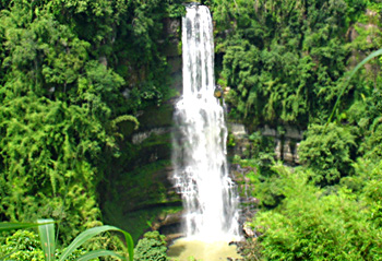
Serchhip District consists of a number of beautiful towns and villages. Thenzawl is the second biggest town after Serchhip. It is one of the few flat areas with beautiful grassy landscape. There is a spectacular waterfall called Vantawng Khawhthla near Thenzawl. This beautiful stepped fall is easily accessible by road, and this place a magnificent view of the nature. Serchhip District is connected to the state capital by road network. It is around 112 kms from Aizawl. Several modes of transportation are available from Aizawl to Serchhip.
Serchhip District has one College and one Higher Secondary School, 15 High Schools, 73 Middle Schools and 84 Primary Schools.


