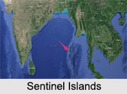
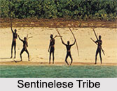
 Sentinel Islands is one of the most isolated places on earth. This isolated island is a residence to the "Sentinelese" people, the most dangerous tribe in the world. These are a part of the Andaman Islands chain and they are divided between north and south sections.
Geography of Sentinel Islands
Sentinel Islands lies in 36 kilometres west of the town of Wandoor in South Andaman Island, 50 kilometres west of Port Blair and 59.6 kilometres north of its equal South Sentinel Island. It is situated in the Bay of Bengal.
Tribe of Sentinel Islands
Sentinelese is the indigenous people of Sentinel Islands. They are among the preceding people to stay on virtually untouched by the modern civilisation. Sentinelese keeps up an essentially hunting society existing throughout hunting, fishing and collecting wild plants. Sentinelese wears no clothes, but wear leaves, fibre strings or similar material as ornaments. They aggressively reject to contact with the groups of different nationalities who have tried to communicate with them, from imposing European explorers to the Indian coastline guard.
 On January 4, 1991, 28 people which including men, women and children approached the Sentinel Islands and said that Sentinelese willingly came forward to meet them. Though, after several failed attempts to build contacts with them since 1964, Indian government has at last backed away. In 2005, the administration of Andaman and Nicobar said that they have no purpose of interfering in the existence of the Sentinelese tribe. Also, the Indian navy implemented a 3 mile buffer zone to keep tourists and explorers away.
Culture of Sentinel Islands
People of the Sentinel Islands keep up a hunting culture. Their houses are either shelter-type huts with no side walls and a floor, sometimes laid out with palms and leaves. Their arms consist of javelins and a type of flat bow. Tools contain adzes, pounding and smiting stones, and different thinly woven baskets for small-grained or larger goods, as well as bamboo and wooden boxes. Food of the Sentinel Islands consists chiefly of plants collected in the forest, coconuts, which are regularly found on the beaches as pigs, presumably, other wildlife, etc.
Present Situation of Sentinel Islands
Sentinel Islands is officially a part of the Indian Union Territory of Andaman and Nicobar Islands. The Sentinelese use absolute sovereignty over their affairs. The connection of the Indian authorities is limited to rare monitoring.


