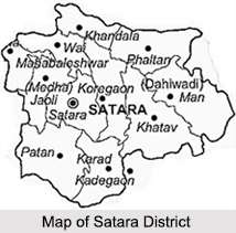
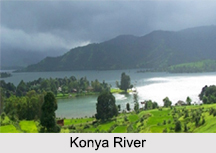
 Spreading over a total area of 10, 484 sq. km, the Satara District is situated in the western Indian state of Maharashtra and the common language spoken here is Marathi. It is situated in the river basins of the Bhima and Krishna River and the main rivers of the district are Koyna and Krishna, which is one of the three largest sacred rivers of southern India. The geography of Satar District is marked by a physiography showing immense variation and a variety of landscape.
The Satara district is divided into 11 Tehsils and 11 Panchayat Samitis namely Satara, Karad, Wai, Mahabaleshwar, Phaltan, Man, Khatav, Koregaon, Patan, Jaoli and Khandala. There are 8 Nagar Palikas or Municipalities in Satara that include Satara, Karad, Wai, Mahabaleshwar, Panchgani, Rahimatpur, Phaltan and Mhaswad.
History of Satara District
According to historical inscriptions as old as 200 BC reveal that the oldest known place in the Satara District is Karad, also known as Karhakada. It is also believed that in the 13th year of the Pandavas exile, they lived in the town of Wai, which is known as Viratnagari. The Satara District is part of the oldest Rashtrakuta history, which is believed to be from ancient Kuntala in the valley river Krishna. There are several great warriors, kings, saints and great personalities who have contributed to the rich heritage of the district. It had seen the rule of the Mauryans, the Satvahanas, and the Nizam Shahi dynasty and lastly it came under the Maratha Empire before it was annexed by the British Empire.
 Demographics of Satara District
As per the reports of Census India 2011, the total population of the Satara District was 3, 003,741 out of which male and female were 1,510,842 and 1,492,899 respectively. The Satara District has a sex ratio of 988 females for every 1000 males and a literacy rate of 82.87 percent. The district has a population density of 287 inhabitants per sq. km with a population growth rate of 6.93 percent. The primary religion followed here is Hinduism followed by 89.63 percent of the total population.
Education in Satara District
Another important aspect of the Satara district is its well planned educational system. The district is home to the first Sainik School of India, which was inaugurated on 23rd June, 1961. The school serves as a famous landmark in the Satara town and has sent hundreds of students to the National Defence Academy. The other famous educational institutions located in Satara include Bhimabai Ambedkar Kanya Vidyamandir, Dr. J. W. Airan Academy (formerly known as Narmada Education Academy), Kanyashala, Nirmala Convent High School, Sainik School, Saint Paul`s School, Lal Bahaddur Shastri College, Satara Azad College of Education, Chhatrapati Shivaji Arts College, Dhananjay Gadgil Vanijya Mahavidyalay, Ismailsaheb Mulla Law College, Karmaveer Bhaurao Patil College of Engineering, Yashawantrao Chavan Institute of Science Satara, Satara Polytechnic, Satara College of Pharmacy, etc. Health service is provided to the people of Satara through a General Hospital, cottage hospitals, primary health centres, primary health sub centres, rural hospitals, Ayurvedic Dispensaries, etc.
Visiting Information on Satara District
The Satara railway station is the closest at a distance of 22.7 km from the district headquarters and the Pune International Airport is the nearest at a distance of 138 km. The Satara District is well connected via roadways and has the National Highway 4 running through it.


