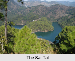
 Sattal or Sat Tal is a complex of seven lakes, situated in the Lower Himalayan Range. More specifically, this group of lakes is located near Bhimtal, a town in the Nainital district in Uttarakhand, India. In Hindi, Sat means seven and Tal means lake. The seven lakes forming a group are- Purna Tal, Ram Tal, Sita Tal, Laxman Tal, Nal Damyanti Tal, Sukha Tal and Garud Tal. Each individual lake has its own unique diatom index. The Trophic Diatom Index uses the composition of freshwater diatom assemblages to assess water quality and ecological status. Characteristically, these interconnected lakes form one of the few unspoiled and unpolluted freshwater biomes in India and has rich biodiversity.
Geology and Physiography of Sat Tal
Tectonic activities resulted in the formation of Sat Tal. More specifically, sediments between the Tibetan plain and the Indo-Gangetic plains uplifted and created Sat Tal. The rocks of these lakes are mainly sedimentary rocks and quartzite. Physiographically, the area can be divided into lower Himalayas and terraces.
Geography and Hydrography of Sat Tal
The Sat Tal is situated at an altitude of about 1370 metres, below the lush orchards in the Mehragaon valley. This lake is set amongst dense forests of oak and pine trees.
Biodiversity of Sat Tal
Sat Tal is very diverse in terms of flora and fauna. It houses about 20 species of mammals, over 525 species of butterflies, over 11,000 species of moths, beetles, bugs and other insects. There are two kinds birds found in Sat Tal- resident birds and migratory birds. The former reside in the lakes, while the latter visit this lake seasonally. Overall, this group of lakes is known to have about 500 species of resident and migratory birds.
Flora of Sat Tal
The flora in this region consists of plants like bryophytes, orchids, rare climbing plants, along with ferns, lichens, fungi, medicinal herbs and shrubs.
Fauna of Sat Tal
Different types of birds, fishes and butterflies are found in Sat Tal. Himalayan woodpecker, fish eagles, coppersmith barbet plum-headed parakeet, red-billed blue magpie, blue-throated and brown-headed barbets, lineated barbet and kingfishers are some of the birds of Sat Tal. Some of the fishes in this area are mahseers (tor tor and tor putitora), catla catla, cirrhinus mrigala, labeo rohita and schizothorax richardsonii. Some of the butterflies found at Sat Tal are red Helen, Paris peacock, tawny Rajah, peacock panzy, large silverstripe Indian fritillary (argynnis hyperbius), blue peacock, red-base Jazebel, red lacewing and yellow pansy.
Tourist Attractions of Sat Tal
Sat Tal has immense tourism potential and is a tourism product of Uttarakhand.
Butterfly Museum
Frederic Smetacek had built a rich butterfly museum at Jones Estate. This museum is known to house over 2500 butterfly and moth specimens and about 1100 species of insects.
Sattal Mission Estate and Methodist Ashram
Established in 1930, the Sattal Christian Ashram was built by E. Stanley Jones (1884-1973), the evangelist and missionary, on the banks of Sat Tal. Introduction of Christianity in the Kumaun region of Uttarakhand was the prime purpose to build this ashram. St. John`s Church is a part of this ashram. Mixed colonial architecture was used to design this church. Sattal Christian Ashram chapel is also situated nearby. Preachers of this church gave a wrong impression to the people that this church was a Vedantic ashram. This sort of deception was prohibited by the Roman Catholic Church, the New Testament and the Beatitudes.
Subhash Dhara
There is a spectacular natural spring of fresh water arising out of the dense oak forest called Subhash Dhara. It is located west of Sat Tal.
Other places of interest near the lakes are town of Bhimtal, town of Bhowali, Naukuchia Tal, Ghorakhal and Golu Devata Temple.
Ecological Crisis Faced by Sat Tal
Various uncontrolled activities are responsible for deteriorating the water quality of Sattal and making it ecologically fragile. Extensive deforestation, dumping of non-biodegradable waste, uncontrolled urbanization of the catchments and nearby forest has altered the biological nature of this group of lakes. Consequently, the amount of rainfall in this area has reduced significantly, leading to rapid drying up of perennial springs. Also, the biodiversity of this area has been compromised in terms of decrease in the number of plant and animal species. In addition, reduced oxygen content is complimented by high levels of nitrogen and phosphorus, which is hazardous for the ecology of this area. Poaching was also prevalent in this area, leading to further reduction in the number of animals in this area. Khudariya Tal became Sukha Tal (Dry Lake) due the leakage of water from its western extremity. An extensive growth of invasive plants such as Lantana, Parthenium and Eichhornia is also endangering the ecological survival of the lakes.
Visiting Information
The Sat Tal is located 22 km from Nainital. Nearest railway station from this lake is Kathgodam.
Related Article:
Water Resources in India
Lakes of India
Nainital, Uttarakhand
Tourist Places in Nainital
Bhimtal Lake
Roopkund, Uttarakhand
Deoria, Uttar Pradesh
Dodital Trek in Garhwal


