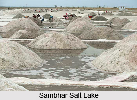
 Sambhar Salt Lake is India`s largest salt lake. On the eastern end, the lake is divided by a 5-km long dam. To the east of the dam are salt evaporation ponds which have been used from centuries, to make salt. To the east of the dam is a railroad that provides access from the Sambhar Lake City to the salt works. The Sambhar lake city is the largest of human settlements around the lake. There is a lot of mythology and legend connected to Sambhar. It is believed to have been gifted by the Goddess Shakambari to the local people 2500 years ago.
Location of Sambhar Salt Lake
It is located 96 km South West of the city of Jaipur. It is situated 64 km North East of Ajmer along National Highway 8 in Rajasthan.
History of Sambhar Salt Lake
The kings of Jaipur and Jodphur owned the lake in turns. Later, it was leased to the British. The Government of Rajasthan took over the lake post-Independence.
Highlights of Sambhar Salt Lake
The lake is an extensive saline wetland, with water depths fluctuating from just a few centimetres (1 inch) during the dry season to about 3 meters (10 feet) after the monsoon season. It is the source of most of Rajasthan`s salt production. More than 30 clusters of villages encircle the lake. Sambhar, Gudha, Jabdinagar, Nawa, Jhak, Korsina, Jhapok, Kanseda, Kuni, Tyoda, Govindi, Nandha, and Sinodiya are some of the major settlements.
In addition to these, the lake has been designated as a Ramsar site, which is a recognized wetland of international importance because the wetland is a key wintering area for tens of thousands of flamingos like the Northern shoveller and black headed gull and other birds that migrate from northern Asia. Even some 45 species of aquatic birds including ducks, geese and shorebirds have been recorded.
Mythological Significance of Sambhar Salt Lake
Sambhar Salt Lake finds mention in the mythological epic, `Mahabharata`.
According to History, the lake was the part of the kingdom of the demon king Brishparva. It is believed that the demon`s priest Sukracharya lived here and the marriage between his daughter, Devayani, and King Yayati also took place here.
As per Hindu tradition, the goddess of the Chauhan Rajputs, `Shakambari Devi`, first converted the town to a plain of precious metals. Later, the Goddess had to convert the town of metals into a town with a lot of salt as people were not satisfied with the previous boon. Thus, the Salt Lake is known to have had its beginnings from here.
Threats to Sambhar Salt Lake
•Shortage of water and increasing desertification.
•Grazing pressure from domestic animals from some 20 villages located around the lake.
•Illegal hunting by local people.
However, apart from these problems, though hunting has been banned in the area, no special conservation measures have been taken. Also a comprehensive ecosystem study is urgently required for coming up with a management plan for the long tem.
Connectivity of Sambhar Salt Lake
Sambhar is well connected by road with all nearby towns. The nearest airport is Jaipur airport. The closest railhead is the Sambhar Salt Lake station.


