 Samba is a city and Municipal Committee in Samba district in Jammu and Kashmir.
Location of Samba
Samba is the headquarter of Samba District of Jammu and Kashmir.
History of Samba
Samba was principality established somewhere in 1400 A.D. As per folklore Malh Dev, the younger son of Rai Saidu of Lakhanpur was the founder of Samba principality, who married into the family of Ghotar a local tribesman. After his marriage he stayed at Samba and made himself the master of the tract with Samba as its capital. Samba ultimately came under the supremacy of Jammu, during the period of Hari Dev, in 1816 A.D. and in 1846 A.D. it became an integral part of the Jammu and Kashmir State. Samba is the place in Samba district. This town was part of Jammu district. The main industrial area of Bari Brahmana which earlier used to fall under Jammu district has now been included in Samba district. It is said that the town derives its name from the Sambyal Rajput clan who were its inhibitors. The town had a long tradition of involvement in the Indian Army.
Geography of Samba
Samba is located at 32.57 degree North to 75.12 degree East. It has an average elevation of 384 metres (1259 feet).Samba town is situated on range of Shivalik hills alongside the National Highway 1-A / on the bank of river Basantar at a distance of forty km from Jammu city. District Samba is bounded by Udhampur District in the North, District Kathua in the East, Tehsils Jammu and Bishnah of District Jammu in the west, while on the southern side it has International Border with Pakistan. About two third of the area of Tehsil Samba is Kandi and rain fed. The area on southern side downside the national highway is irrigated through Ravi Tawi Irrigation canal network and contributing towards major cereals crop and vegetable cultivation as special focus has been assigned by the govt. of India, Ministry of Water Resources through Command Area Development Department.
Climate of Samba
The climate of Samba is sub tropical zone and is hot and dry in summer and cold in winter. It is the foot hills of the mountains. Nights are bit cooler than that of neighbouring areas of Punjab. The temperature ranges between 2 degree Celsius and 42 degree Celsius.
Economy of Samba
Samba is the economically best place in Jammu and Kashmir. It is a modern industrial complex established on the bank of river Basantar at Samba named as Industrial Growth Centre. A number of small & medium industrial units have been established and have provided job opportunities not only to the educated unemployed youths, but also to the labourers, skilled and un-skilled by starting their own ventures in the private sector.
Tourism in Samba
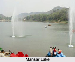
Samba is the best place for nature tourism. Mansar Lake is situated on the Samba - Udhampur Road at a distance of twenty two km from Samba. Mansar Lake is surrounded by small hills with different Hindu Gods and Goddesses Temples and also attracts a large number of tourists as well as religious pilgrims in the area. A tourist complex comprising five tourist huts and rooms situated on the bank of the Lake provides accommodation to the tourists and the visitors. The State Government has also established development authority known as Surinsar-Mansar Development Authority which is responsible for implementation of tourism developmental projects in all the four tourist places. Purmandal is a religious place situated at a distance of thirty nine km from Jammu and also connected with Samba via Purmandal-Utterbani -Vijaypur road. Purmandal is known as "Chotta Kashi", having old Shiva temples which has significant religious importance and surrounded by the Shivalik Hills that possess a natural beauty. Utterbani is another religious place situated on the bank of legendary Devika and is having centuries old temples located at a distance of five km from Purmandal.
Related Articles
Cities of Jammu and Kashmir
Culture of Jammu and Kashmir
Costumes of Jammu and Kashmir
Temples of Jammu and Kashmir
Kashmir, India
Samba District, Jammu and Kashmir
