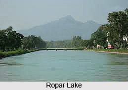
 Ropar Lake is an artificial fresh water lake and it consists of lacustrine wetland. The area of Ropar Lake is the home of nine mammals, 154 migratory birds, 35 fish, 9 arthropod, 11 rotifer, 9 crustacean and 10 protozoan species, which makes this lake ecologically balanced.
This ecologically maintained aquatic zone is located in foot hills of Shiwalik of Himalayas which is known as Lesser Himalayas. Ropar Lake which is widely known as Ropar Wetland was created on 1952 on the Sutlej River in Punjab. This wetland has the main function in providing the water for irrigation, drinking and industrial bases. The endangered turtle Chitra indica and the threatened snake Python molurus are the valuable residents of this lake.
Ropar Wetland or Ropar Lake is a popular tourist attraction for bird watching and boating. A tourism complex is located within the wetland boundary, which is run by the Punjab Tourism Development Corporation. A Boat Club is also functioning to provide amusement and adventure to the nature lovers.
Ropar Wetland or Ropar Lake is easily accessed through Chandigarh, which connects the rest of the country, as this lake is situated 45 km northwest of Chandigarh City, in Rupnagar district and Nawanshahr district of Punjab.
The total area covered by the Wetland is 1365 hectors, which includes 800 hectors area of the river and the reservoir, 30 hectors of forest area named as Sadavarat Forest and 30 hector under marshy plants. Ropar Wetland or Ropar Lake is surrounded by hills in the north-west and by plain area in the south and south east of Rupnagar. The agricultural crops such as wheat, rice, sugarcane, sorghum etc., are grown in the adjacent farm lands in the area surrounding the wetland. The hills have thin vegetation and are exposed to intensive grazing.
Flora and Fauna of Ropar Lake
Ropar Wetland or Ropar Lake is rich in flora and fauna. A total of 19 species of trees and 14 species of bushes and grasses are present. Of these, the tree species are Acacia catechu, Ameles modesta, Acacia nilotica, Albizzia lebbek, Azadirachta indica, Bombax ceiba, Cassia fistula, Dalbergia sissoo, Eucalyptus tereticornis, Ficus benghalensis, Ficus religiosa, Mangifera indica, Melia azedarach, Moringa oleifera, Morus indica, Prosopis juliflora, Salix willow, Syzygium cumini (Jambul) and Zizyphus jujuba. Some of the major aquatic inhabitants of Ropar Wetland or Ropar Lake are Labeo gonius Seerha; Labeo calbasu Kalbans or Dhai; Labeo dero Gid; Labeo dyocheilus (Kunni); Katla katla Thal; Cirrhinus mrigala Mori; Puntius sarana Puthi; Cyprinus carpio communis (Common Carp); Cyprinus carpio spacularis (Mirror carp); Ceenopharyngodon idelle (Grass Carp); Wallago attu Mali; Aorichthys seenghala Sangarha; Mastacembelus armatus Sam (Tire track eel); Ambasis ranga Shisha Mach; Channa punctatus Dolla (Snake headed fish); and Channa striata (Curd). Several species of birds have been recorded which include 49 species of local birds, 11 species of migratory birds, 3 species of rare birds and 54 species of common birds. Some of the rare birds are Dinopium benghalense; Golden-backed Woodpecker; Megalaima haemacephala; Crimson-breasted barbet; and M. zeylanica Green barbet.


