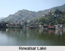
 Rewalsar Lake is located in the state of Himachal Pradesh in India. More specifically, it is situated on a mountain spur, about 22.5 km south-west from Mandi district. It is also called the "Tso Pema Lotus Lake" by the Tibetan Buddhists. Characteristically, it is a square-shaped mid-altitude lake and is also held sacred. Being a holy lake, fishing is prohibited here.
History of Rewalsar Lake
A number of interesting historical facts are associated with the Rewalsar Lake. It is known that a great Indian teacher and tantric named Padmasambhava, left for Tibet from here. He was also known as `Guru Rinpoche`, the Precious Master, by the Tibetans.
History highlights that Guru Padmasambhava and Mandarava, the daughter of the then king of Mandi, were romantically associated with each other. Mandarava decided to run away with Guru Padmasambhava, but the king came to know about this decision. He cursed them to die in a fire. Padmasambhava protected himself and Mandarava by magically converting the funeral pyre into a lake of sesame oil, surrounded by a ring of fire. In doing so, he used his supernatural powers. In the middle of the fire bloomed a huge lotus on which Guru Padmasambhava was seated, surrounded by rainbows and clouds.
It is here that sage Lomas did penance in devotion to Lord Shiva. The Sikh guru, Gobind Singh (22 December 1666 - 7 October 1708), the tenth Guru of Sikhism, also resided here for a month.
Geography and Hydrography of Rewalsar Lake
The elevation of Rewalsar Lake is about 1,360 m, above sea level and its shoreline is about 735 m. Situated at a considerable altitude, the climate of this lake can be a matter of concern for some. In winters, temperatures can hover around freezing point, when heavy woollens would be required. During summers, the climate is hot and cottons are generally preferred by the people visiting this lake. This lake is surrounded by woodland, high hills and dense vegetation. It is known to appear like a dark jewel, nestling among the high hills of the Indian Himalayas.
This lake also has floating islands. These islands are formed by reeds. It is believed that all the seven reeds in this lake can be moved by breeze or prayer. It is also believed that the spirit of the Buddhist monk Padmasambhava, resides in these reeds.
Surrounding of Rewalsar Lake
The Rewalsar Lake lies in the hollow of a mountain and is considered to be a holy lake by 3 communities- Hindus, Sikhs and Buddhists. This lake is an abode of 3 Hindu temples, dedicated to Lord Krishna, Lord Shiva and sage Lomas. There is a 12 m-high statue of Padmasambhava, overlooking the lake. Drikung Kagyu Gompa, an academy for Buddhist studies, is also located near the lake. It houses the statue of Sakyamuni or Gautama Buddha. Also a Gurudwara, dedicated to Guru Gobind Singh, is in the vicinity of the lake. It was built in 1930 to honor Guru Gobind Singh`s visit in 1738 to Rewalsar. Some of the pilgrimage sites near the lake are Padmasambhava Cave, Naina Devi Temple, Zigar Drukpa Kagyud Institute, Drikung Kagyud Gompa, Jigar Monastery and Kunt Bhyog. The Kunt Bhyog Lake is located above Rewalsar Lake. There is also a small zoo near the lake.
Visiting Information
Summer, from March to October, is generally considered to be the best season to visit this lake At Pathankot, the broad-gauge railhead is located at a distance of about 210 km from the lake. The narrow gauge railway at Pathankot connects Joginder Nagar, which is about 56 km from Mandi. From Chandigarh, one can drive directly to Mandi via Ropar and Bilaspur. This distance is about 203 km. The nearest airport at Bhuntar is about 59 km.
Related Articles:
Lakes of India
Water Resources in India
Renuka Lake
Dal Lake
Prashar Lake
Chandra Taal
Khajjiar Lake
Nako Lake


