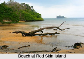
 Red Skin Island is situated within the Mahatma Gandhi National Park at the northern part of Port Blair, capital of Andaman and Nicobar Islands. It is also known as Bilwil Ai Pong or Bilwilaipang. There is abundance of red coral lining on the coastal area of this island. These corals thus lend reddish colour to the sea water. Therefore, this island is called the Red Skin Island. It is small and uninhabited. When Jolly Bouy Island becomes unsafe during the monsoons, Red Skin Island in the vicinity becomes a viable option to traverse this island in the monsoons. Overcrowding thus becomes a usual phenomenon in the scorching sun and excessive humidity, a characteristic of the monsoons. So it is recommended to visit this island off-season. It is not open throughout the year for the protection of coral life. As many other islands on the Andaman and Nicobar Islands, Red Skin Island is characterized by virginity and unpolluted environment which compliments the rich diversity of corals and reefs living within.
People of Red Skin Island
Local people only visit this island to earn a livelihood through tourism and for helping the visitors with water sports activities. In spite of scarcity of human population, this island is very popular among tourists.
Tourism in Red Skin Island
The Red Skin Island remains barren, but comes to life when tourists attend it to experience and enjoy its underwater coral wealth and unspoiled beaches. Dolphin sighting is also common among the visitors of this island. Dolphins merrily playing in the emerald waters of the sea captivate the attention of the tourists. Glass bottom boats are used to show the under water marine life. The under water corals are so many in number near Red Skin Island that the island is often called Under Water Coral Garden. People can also enjoy the running sea view while travelling through the boat. Its beach is extremely narrow. This island boasts of long coastal line and from here one can have a spectacular view of nature which is not obstructed by any force and boundaries. It is a good place for beginners of snorkelling because the water is shallow in places. While snorkelling, if the temperature of the island is low, then it is recommended to wear wet suit to enjoy the lustre of the sea life. Besides Snorkelling, one can opt for swimming if the temperature is low. Tourists are not permitted to stay on this island after day light hours. To promote eco-tourism, carrying plastic bottles and plastic bags is strictly prohibited. This island is thus termed as a no plastic zone. If one needs to carry drinking water or mineral water then he would have to rent a water container at the jetty and pour the water from plastic bottles into the container and leave the plastic bottles in the vehicle.
Nearby Attractions at Red Skin Island
Some of the renowned attractions that surround the site of the Red Skin Island are Corvyns cove, Vetrimalai Murugan temple, Roman Catholic Church, Sri Karpaga Vinayakar Temple, Jolly Buoy Island, Japanese Bunker, Sagarika government emporium, Zoological survey of Indian Museum, Chatham Saw Mill, Marantha full gospel church and many more.
In this region, the Marine National Park was an initiative by the Forest Department of Andaman and Nicobar Islands to preserve the indigenous natural life of the Andaman and Nicobar islands. The Marine Park encompasses 150 islands and an area of approximately 280 square kilometres, Red Skin Island is one of the best rated islands.
Visiting Information
Red Skin Island is open from May to October. These are tentative months and can change without any prior notice. To avail the tour of Red Skin one needs to acquire a permit one day before the trip from the Forest Department. Red Skin Island can be reached by a ferry from the Wandoor Jetty which is right by the Cellular Jail at Port Blair. From there they are transferred in glass bottom boats which show under water marine life.
Related Articles:
Cellular Jail
Marine National Park
Indian Beaches
Andaman and Nicobar Islands
Port Blair
Scuba Diving and Snorkelling in India
Andaman and Nicobar Islands Tourism
Mahatma Gandhi National Park


