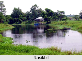
 Rasikbil or Rasikbeel is a small and stunning lake located at the foothill of Sintura Hill of the great Himalaya in Cooch Behar district of the East Indian state West Bengal. The lake is in fact a low water land or swamp where water is available all around the year. The lake is a birding parasite where a number of magnificent birds flock around and make their nests in the surrounding trees. The lake covers an area of 175 hectare and is notified as a Bird Sanctuary by the forest department.
Geography of Rasikbil
Rasikbil is situated at a distance of 34 kilometres from Alipurduar, 212 kilometres from Siliguri and 45 kilometres from Cooch Behar. The average temperature of the place ranges from 42 to 14 degree Celsius. Average rainfall of the region has been recorded to be 320 centimetres.
Avifauna of Rasikbil
Rasikbil host a vast variety of birds which are both native as well as migratory. Migratory birds generally arrive here during winters.
 Prominent birds which are spotted here include different varieties of Parrots, Owl, Kingfisher, Spoonbill, Ibis, Storks, Cormorants and many more. Gadwall, Large Cormorant, Small Blue Kingfisher, Stork Billed Kingfisher, Pied Kingfisher, Northern Lapwing, Grey Headed Lapwing, Wigeon Duck, Pintail, Shoveler, Red Crested Pochard, White Eyed Pochard, Common Teal, Beel- Lesser Whistling Teal etc are also the common members of Rasikbil.
Tourism in Rasikbil
Rasikbil is an ideal place for ecotourism. Apart from being an excellent bird watching site the place is also famous for a crocodile rehabilitation centre and a deer park is located. A Tortoise rescue centre, a large aquarium, aviary, a python house and a leopard house form other tourist attractions. A tribal village is also there near Rasikbil. Boating can also be enjoyed in Rasikbil. Nearby tourist destinations of Rasikbil enlist the Buxa Tiger Reserve famed for Royal Bengal Tiger. Rasikbil is in fact a part of the buffer area of the tiger reserve. Cooch Behar, 45 kilometres away, holds historical significance and houses a few heritage constructions. There is a watch tower at Rasikbil which offers enchanting views of sunset and sunrise.
Visiting Information
Rasikbil can be visited throughout the year. It can be reached from Siliguri through roadways; however break journey is required by halting at Cooch Behar or Alipurduar. Buses or taxis can be availed for this. Nearest railway station is at Kamashkhaguri, which is just 6 kilometres away from the lake. Since only a few trains have stoppage here, Jalpaiguri, Siliguri and Cooch Behar railway stations form the major railheads. Bagdogra is the nearest airport to reach Rasikbil.


