Home > Indian History > Geography of India > Raniganj Coalfield
Raniganj Coalfield
Raniganj Coalfield is the second largest coalfield of the country. A vast portion of the coal from this coalfield is also exported to foreign countries.

Share this Article:

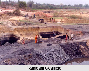
Raniganj CoalfieldRaniganj Coalfield is situated in Bardhaman district, West Bengal, mainly in Durgapur and Asansol subdivisions. The coalfield however also spans over the neighbouring districts like Bankura, Dhanbad, Birbhum and Purulia. It covers a vast area of 443.50 square kilometres and possesses coal reserves of several million tonnes. In terms of coal reserves, it is considered as the second largest coalfield of India.

In India, coalmining was initiated in the Raniganj Coalfield. In 1774, coal was found near Ethora, which is presently known as Salanpur community development block, by Suetonius Grant Heatly and John Sumner of the British East India Company. Back then, exploration and mining activities were done quite haphazardly. In 1820, regular mining activity was commenced by Alexander & Co, an agency house. Later in the year 1835 the collieries were brought and led by Carr and Tagore Co. which belonged to Prince Dwarkanath Tagore. Raniganj Coalfield served as the main coal producer of the country throughout the 19th century and in the major part of 20th century.

In 1843, on the request of William Princep, Carr and Tagore Co. collaborated with Gilmore Hombray and Co. and began coal mining venture. The headquarters was situated at Sanctoria. In the course of time, Raniganj Coalfield was owned by a number of companies which carried out mining activities in the field. In 1975, a subsidiary of Coal India Limited, known as Eastern Coalfields Limited, was formed, which over took all the private collieries of Raniganj Coalfield.

Coal seams of Raniganj Coalfield can be categorized into two blocks viz. Barakar measures and Raniganj measures. Raniganj measures covers the areas of Raniganj-Pandaveswar, Jhanjra, Kenda, Kajora, Bankola, Kunustoria, Sripur, Satgram, Salanpur, Sodepur whereas Barakar measures covers Mugma and Salanpur.

Raniganj Coalfield is famous for producing the best type of non-coking coal in the country. Several heat intensive industries including Refractories, Ceramic, Forging, Glass etc are dependent on Raniganj Coalfield. A major portion of coal reserves of this field are exported to foreign countries. It is also a vast reservoir of iron ore in the form of nodules. Apart from this fire clay, pottery clays, brick clays are also found in the coalfield. Manganese, calcium carbonate, laterite and bauxite are also common in Raniganj Coalfield.


Share this Article:

Related Articles

More Articles in Geography of India


Geography of Uttar Pradesh
The fourth largest State in India UP is located in the Northern part of India whose area is 2,36,286 sq Kms.
Geography of Maharashtra
Covering an area of 308,000 sq. km, Maharashtra, the third largest state in India.
Geography of Kerala
Geography of Kerala includes plains, hills, valleys and coasts. With the Arabian Sea in the west, the Western Ghats in the east and networked by several rivers, Kerala enjoys diverse geographical features.
Geography of West Bengal
The geography of West Bengal is unique with high peaks of the Himalayan range in the north, the Bay of Bengal in the south and the remaining region is covered with both plains and plateaus.
Geography of Jharkhand
Geography of Jharkhand is comprised of the rich mineral resources and the highly agricultural prospect in this state.
Geography of Sikkim
Geography of Sikkim is characterised by a vast array of magnificent hillock that extends from one corner of the state to the other.
Geography of Meghalaya
The suitable climate, highland plateaus, rivers and the flora and fauna together forms the geography of Meghalaya.
Geography of Mizoram
Mizoram is surrounded by hills, valleys, rivers, waterfalls and lakes. The hills range from 1000 meters to 2000 meters. Rivers, lakes and waterfalls also play major role in forming the land of Mizoram.
Geography of Jammu & Kashmir
Jammu and Kashmir is encompassed by valleys. Some of the dominant valleys of the state are Kashmir Valley, Tawi Valley, Chenab Valley, Poonch Valley, Sind Valley and Lidder Valley etc. Jhelum River is the only major Himalayan River which flows through the Kashmir valley. Indus, Tawi, Ravi and Chenab Rivers are the major ones flowing through the region.
Geography of Daman and Diu
Daman and Diu is situated on the west coast of India and are the smallest union territories of India.
Geography of Goa
Geography of Goa occupies a prime location along the Konkan coastal belt on the western coast of India. The state is bordered by Maharashtra in the north and Karnataka in the south. The Western Ghats in the east contribute to the flora and fauna of Goa.
Geography of Arunachal Pradesh
Geography of Arunachal Pradesh reveals that it is a hilly tract nestled in the foot of Himalayas.
Geography of Kutch
Geography of Kutch District is covering an area of 45,612 km. Kutch District is the largest district in the state of Gujarat.
Geography of Ladakh
Geography of Ladakh mainly comprises the huge Karakoram Range with long stretch of cold desert which mark the region separately from the rest of the states of Indian subcontinent. Surrounded with the mountain ranges from all corners this small region separates Indian subcontinent from rest of the Asian continent.
Geography of Rajasthan
Geography of Rajasthan defines the dry topography with arid climate of the western mountain region.
Geography of Tamil Nadu
The Indian state of Tamil Nadu is located in the Northern hemisphere in the hot zone.